
Most islands are easy to understand on a political map.
Japan’s Honshu belongs to Japan.
Madagascar belongs to Madagascar.
Iceland is a single country.
But some of the world’s largest islands are divided by international borders.
On a few, the border separates two sovereign states.
On others, three countries share the same landmass.
And Cyprus is even more complicated, with an internationally recognized republic, a de facto northern administration, British sovereign territory and a United Nations buffer zone all existing on one relatively small Mediterranean island.
These divided islands reveal something important:
Coastlines may create natural boundaries, but political borders are products of history.
Colonialism, war, treaties, independence movements and migration have divided some islands almost as dramatically as continental regions.
Here are seven of the world’s largest examples.
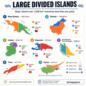
1. New Guinea — About 785,753 km²
New Guinea is the largest divided island on Earth and the second-largest island in the world overall, after Greenland.
It covers approximately:
785,753 square kilometers. (Wikipedia)
Today it is divided between:
Indonesia in the west
and
Papua New Guinea in the east.
The international border runs almost vertically through the island for much of its length.
Western New Guinea
The western half belongs to Indonesia and today includes several Indonesian provinces.
This region is often collectively referred to geographically as Western New Guinea.
Indonesia acquired control following the end of Dutch colonial rule and a complicated international process during the 1960s.
The area’s political status and history remain sensitive subjects.
Papua New Guinea
The eastern portion became the independent country of Papua New Guinea in 1975.
Its capital, Port Moresby, lies on the island’s southeastern coast.
But the island’s political division is almost simple compared with its cultural geography.
New Guinea is one of the most linguistically diverse places on Earth.
Hundreds of languages are spoken across its mountains, valleys and forests.
Mountainous terrain historically isolated communities from one another, allowing extraordinarily diverse cultures and languages to develop.
A Border Through One Enormous Ecosystem
The political line separates governments.
It does not divide the island’s natural geography nearly so neatly.
Mountain ranges, forests, rivers and Indigenous cultural regions extend across the border.
New Guinea therefore demonstrates one of the central themes of divided islands:
Political boundaries can be far younger than the human and ecological landscapes they cut through.
2. Borneo — About 748,168 km²
Borneo is the world’s third-largest island and the only one of these giant islands divided among three sovereign countries.
Its area is approximately:
748,168 km². (Store norske leksikon)
The three countries are:
🇮🇩 Indonesia
🇲🇾 Malaysia
🇧🇳 Brunei
Indonesia Has the Largest Share
Most of Borneo belongs to Indonesia.
The Indonesian part is commonly called Kalimantan and is divided into several provinces.
It covers roughly the southern three-quarters of the island.
Malaysia Occupies the North
Malaysia controls two major states on northern Borneo:
Sarawak
and
Sabah.
These territories are physically separated from Peninsular Malaysia by the South China Sea.
This means Malaysia itself is split into two major geographic sections:
Peninsular Malaysia on the Asian mainland
and East Malaysia on Borneo.
Tiny Brunei Makes It a Three-Country Island
Then there is Brunei.
The small but wealthy sultanate sits on Borneo’s northern coast, surrounded largely by Malaysia’s Sarawak.
Brunei is famous for its petroleum and natural-gas wealth.
Its presence gives Borneo a distinction few major islands possess:
three independent countries sharing a single island.
Why Borneo Became Divided
The answer lies largely in colonial history.
Different sections of Borneo came under:
Dutch,
British,
and Bruneian influence.
When colonial empires disappeared, those old spheres of influence evolved into the modern borders of Indonesia, Malaysia and Brunei.
So today’s political map still carries the outline of decisions made during the colonial era.
3. Ireland — 84,421 km²
The island of Ireland covers:
84,421 km².
Approximately 70,282 km² belongs to Ireland, while about 14,139 km² forms Northern Ireland, part of the United Kingdom. (Department of Foreign Affairs)
The political division is therefore:
🇮🇪 Ireland
and
🇬🇧 Northern Ireland, United Kingdom
One Island, Two Jurisdictions
The Republic—officially simply Ireland—occupies roughly five-sixths of the island.
Northern Ireland occupies the northeastern portion.
The border stretches for roughly 500 kilometers and has enormous historical and political significance.
How Ireland Was Divided
British rule over Ireland developed over centuries.
The political crisis surrounding Irish independence ultimately resulted in the Government of Ireland Act 1920 and the creation of separate political jurisdictions.
The Anglo-Irish Treaty of 1921 led to the Irish Free State across most of the island.
Northern Ireland remained within the United Kingdom.
That basic division continues today.
The Border Became Especially Important During the Troubles
During the late 20th century, Northern Ireland experienced decades of political violence known as the Troubles.
The conflict involved complex questions of:
British and Irish identity,
constitutional status,
civil rights,
religion,
and nationalism.
The Good Friday Agreement of 1998 dramatically reduced the conflict and transformed political relations.
Today the border is far less visible physically than many international boundaries.
That makes Ireland an unusual divided island:
the political boundary is extremely important historically, yet travelers may cross it without seeing a conventional border checkpoint.
4. Hispaniola — 76,192 km²
Hispaniola is the second-largest island in the Caribbean, after Cuba.
Its area is approximately:
76,192 km². (Wikipedia)
It contains two independent countries:
🇭🇹 Haiti in the west
and
🇩🇴 Dominican Republic in the east.
Few divided islands show such dramatic differences between neighboring countries.
Two Nations With Very Different Histories
Hispaniola was among the first major centers of European colonization in the Americas.
Over time, competing colonial powers divided it.
The western section became associated with France.
The eastern part remained more strongly connected with Spain.
Those different colonial histories helped produce:
different languages,
different political systems,
different cultural identities,
and eventually two independent states.
Haiti
Haiti emerged from one of history’s most consequential revolutions.
Enslaved people overthrew French colonial rule, and Haiti declared independence in 1804.
It became the world’s first independent Black republic and the first state created by a successful large-scale revolt of enslaved people.
Dominican Republic
The eastern side followed a different historical path under Spanish influence before eventually establishing the Dominican Republic.
Spanish is dominant there.
In Haiti, Haitian Creole and French are official languages.
So crossing the border also means crossing a major linguistic divide.
A Powerful Satellite View
Hispaniola has become famous in satellite images because environmental and land-use differences can sometimes appear sharply near sections of the border.
But simplistic claims that one country’s environment stops exactly at the political line should be avoided.
Deforestation, agriculture, rainfall, protected areas, elevation and economic conditions all contribute to the landscape.
5. Isla Grande de Tierra del Fuego — 47,992 km²
At the southern end of South America lies the enormous archipelago of Tierra del Fuego.
Its largest island, Isla Grande de Tierra del Fuego, covers roughly:
47,992 km². (Wikipedia)
It is divided between:
🇨🇱 Chile
and
🇦🇷 Argentina.
Approximately 61% lies in Chile, while roughly 39% belongs to Argentina. (Wikipedia)
A Remarkably Straight Border
Unlike the twisting borders created by rivers or mountains elsewhere, much of the international boundary across Isla Grande follows a relatively straight north-south line.
The western portion belongs to Chile.
The eastern section belongs to Argentina.
Ushuaia Is on the Argentine Side
One of the world’s most famous far-southern cities, Ushuaia, lies on the Argentine side of the broader Tierra del Fuego region.
Argentina’s larger settlements on the main island include Ushuaia and Río Grande.
Chile’s side is much less populated, with Porvenir among its principal settlements.
Why Was It Divided?
Argentina and Chile spent much of the 19th century establishing borders across enormous and sparsely populated southern territories.
An 1881 boundary treaty helped define control in Tierra del Fuego.
The result left both countries with part of Isla Grande.
The border is therefore another example of a political line imposed over a remote natural landscape that had existed for millennia before modern states.
6. Timor — About 30,777 km²
Timor lies at the eastern end of the Lesser Sunda Islands, north of Australia.
The island covers approximately:
30,777 km². (Wikipedia)
It is divided between:
🇮🇩 Indonesia
and
🇹🇱 Timor-Leste.
West Timor
The western portion belongs primarily to Indonesia and forms part of East Nusa Tenggara province.
Its major city is Kupang.
Timor-Leste
Most of the eastern part belongs to the independent state of Timor-Leste.
But the border has an unusual feature.
Timor-Leste also possesses the Oecusse-Ambeno exclave on the northwest coast—territory belonging to Timor-Leste but surrounded on land by Indonesia.
The Timor-Leste government confirms that the country includes Oecusse on the western section of the island, in addition to the main eastern territory and nearby islands. (Government of Timor-Leste)
Colonialism Created the Division
The island was historically divided between:
Portuguese Timor
and
Dutch Timor.
Dutch possessions eventually became part of Indonesia.
The Portuguese colony later evolved into Timor-Leste, though the road to independence was extraordinarily turbulent.
Portugal withdrew in the 1970s.
Indonesia subsequently invaded and annexed East Timor.
After decades of conflict, a UN-backed referendum was held in 1999.
Timor-Leste finally restored independence in 2002.
Today’s island border therefore reflects centuries of colonial competition followed by a much more recent independence struggle.
7. Cyprus — 9,251 km²
Cyprus is much smaller than the other islands on this list.
Its total area is approximately:
9,251 km². (Ministry of Interior, Cyprus)
But politically, it may be the most complicated.
The island includes areas under the control of:
🇨🇾 Republic of Cyprus
the self-declared Turkish Republic of Northern Cyprus
🇬🇧 British Sovereign Base Areas
and a United Nations buffer zone.
The Republic of Cyprus
The Republic of Cyprus became independent from Britain in 1960 and is internationally recognized as the sovereign state representing Cyprus.
It has been a member of the European Union since 2004.
However, its government does not exercise effective control over the island’s northern portion.
Northern Cyprus
The north is administered by the self-declared:
Turkish Republic of Northern Cyprus.
It declared independence in 1983.
But internationally its recognition is extremely limited:
Turkey is the only country that recognizes it as an independent state. (AP News)
That is why the map should avoid presenting the north exactly like an ordinary internationally recognized sovereign country without explanation.
The UN Buffer Zone
Between the two sides runs a United Nations-controlled buffer zone.
The zone extends about 180 kilometers across Cyprus in various sections and is monitored by the United Nations Peacekeeping Force in Cyprus, UNFICYP. (UNIFAB)
It even cuts through the capital:
Nicosia.
Nicosia is often described as Europe’s last divided capital.
Britain Still Controls Sovereign Territory
Cyprus also contains two areas that remained under British sovereignty when Cyprus gained independence:
Akrotiri
and
Dhekelia.
These are not merely foreign military bases rented from Cyprus.
They are legally British Sovereign Base Areas.
Together they occupy roughly 2.8% of the island. (Ministry of Interior, Cyprus)
That means Cyprus contains perhaps the strangest political patchwork on any island of comparable size.
Why Are Large Divided Islands So Rare?
Looking at the world map, something becomes obvious.
There are thousands of islands.
Yet only a handful of very large ones have international land borders.
Why?
Islands Naturally Encourage Political Unity
Water provides an unusually clear geographic boundary.
If an independent state controls an entire island, its frontier is simply the coastline.
There is no neighboring country immediately across a mountain or river.
That often makes unified territorial control easier.
Colonial Rivalries Created Many Exceptions
Most of the islands on this list were divided because competing empires controlled different sections.
Examples include:
Borneo — Dutch and British influence
Timor — Dutch and Portuguese control
Hispaniola — Spanish and French colonial spheres
New Guinea — Dutch, German and British/Australian rule
Modern borders often survived when the colonies became independent.
Other Divisions Came From National Conflict
Ireland and Cyprus followed different paths.
Their divisions arose from complex disputes involving:
national identity,
community allegiance,
colonial history,
and competing constitutional claims.
So not every divided island has the same story.
Which Is the World’s Largest Island Shared by Two Countries?
If Greenland is excluded because it is politically associated with one sovereign kingdom, the answer is:
New Guinea
At approximately 785,753 km², New Guinea is larger than countries such as:
Turkey,
Chile,
and Zambia.
It is almost nine times the size of Ireland.
And yet a single international land border cuts directly across it.
Which Large Island Is Shared by the Most Countries?
Among these examples:
Borneo
is the standout.
It contains territory belonging to three sovereign states:
Indonesia, Malaysia and Brunei.
That makes Borneo one of the world’s clearest examples of how one natural landmass can belong to several very different political systems.
Ireland and Hispaniola Are Especially Interesting Comparisons
Ireland and Hispaniola are relatively close in area:
Ireland — 84,421 km²
Hispaniola — 76,192 km². (Department of Foreign Affairs)
Yet their divisions work very differently.
Ireland is divided between one independent country and one constituent part of the United Kingdom.
Hispaniola contains two completely sovereign states.
Their borders also developed through very different histories.
This demonstrates why the simple phrase “divided island” can describe several radically different political arrangements.
Some Famous Divided Islands Aren’t Large Enough for This Map
If the 1,000 km² minimum were removed, the list would become much longer.
One famous example is Saint Martin/Sint Maarten in the Caribbean.
The tiny island is divided between:
the French collectivity of Saint-Martin
and
Sint Maarten, a constituent country within the Kingdom of the Netherlands.
Other smaller islands around the world also contain international boundaries or complicated political jurisdictions.
So the seven islands in the infographic are not the only divided islands.
They are the largest major examples using the map’s size threshold.
The Bigger Lesson
Political maps encourage us to think of countries as natural units.
But nature did not draw these boundaries.
The mountains of New Guinea do not suddenly change when they reach Indonesia’s border with Papua New Guinea.
Borneo’s rainforest does not know when it crosses from Indonesia into Malaysia or Brunei.
The landscape of Ireland continues uninterrupted across its political boundary.
And the forests and mountains of Hispaniola existed long before Haiti and the Dominican Republic had names.
These borders tell stories about:
empire
war
independence
migration
treaties
and
national identity.
That is why divided islands are so fascinating.
An island looks like one obvious geographical object.
History can turn it into several political worlds.
Source & Accuracy Note
The areas shown on the infographic are broadly consistent with standard geographical references: New Guinea 785,753 km², Borneo 748,168 km², Ireland 84,421 km², Hispaniola 76,192 km², Isla Grande de Tierra del Fuego 47,992 km², Timor approximately 30,777 km², and Cyprus 9,251 km². (Wikipedia)
For Cyprus, the graphic should be described as showing present-day political control, not four equivalent sovereign states. Northern Cyprus is recognized only by Turkey; the Republic of Cyprus is internationally recognized; the UK Sovereign Base Areas remain British territory; and UNFICYP administers/patrols the buffer zone separating the principal sides. (UNIFAB)