
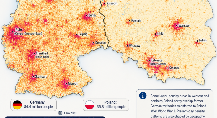
Germany and Poland sit side by side in the heart of Europe.
They are relatively similar in physical size.
Yet their population maps look dramatically different.
As of January 1, 2023, Germany had approximately 84.4 million people, compared with 36.8 million in Poland. Germany therefore had well over twice Poland’s population despite occupying only somewhat more land.
That translates into a striking difference in average density.
Germany had roughly 240 people per square kilometer in 2023.
Poland had roughly 120 people per square kilometer.
In other words, Germany was about twice as densely populated.
But the most interesting part of this map is not the national average.
It is where those people actually live.
Germany contains enormous interconnected belts of settlement stretching between cities.
Poland, by comparison, often appears as a series of brighter urban islands separated by larger areas of lower-density countryside.
And near the modern German-Polish border, history adds another fascinating layer.
Germany and Poland Are Similar in Size—but Not in Population
Germany covers roughly 357,000 square kilometers, while Poland covers a little over 312,000 square kilometers.
On an ordinary political map, they do not look radically different in scale.
Demographically, however, they are.
Eurostat counted:
Germany — 84.4 million
Poland — 36.8 million
on January 1, 2023.
Germany therefore had approximately 47 million more inhabitants.
That difference is larger than the entire population of many European countries.
But simply saying that Germany is more densely populated hides a much more complicated pattern.
Germany Isn’t One Giant Crowded City
Look closely at the German side of the map.
Population is concentrated in several powerful urban and industrial regions.
The brightest concentrations include:
- The Ruhr and Rhine-Ruhr region
- Frankfurt and the Rhine-Main area
- Stuttgart
- Munich
- Hamburg
- Berlin
- Leipzig
- Dresden
Between many western German cities, however, the settlement does not disappear completely.
Instead, smaller cities, towns and suburbs frequently connect major metropolitan regions into broad corridors.
This gives western Germany its distinctive appearance:
not just dense cities, but dense networks of settlement.
The Ruhr Is Germany’s Population Giant
The most spectacular concentration lies in western Germany around the Rhine and Ruhr rivers.
Cities including:
- Cologne
- Düsseldorf
- Duisburg
- Essen
- Dortmund
- Bochum
- Gelsenkirchen
sit remarkably close together.
On a population-density map, individual cities almost merge into one continuous urban zone.
This is the Rhine-Ruhr metropolitan region, one of Europe’s largest concentrations of people and economic activity.
Its density is deeply connected to Germany’s industrial history.
Why the Ruhr Became So Crowded
The Ruhr region contains major coal deposits.
During the 19th and early 20th centuries, coal helped fuel:
- Steel production
- Heavy manufacturing
- Railways
- Machinery
- Chemical industries
- Urban growth
Industrial jobs attracted millions of workers.
Towns expanded into cities.
Cities expanded toward one another.
Railways, canals and later highways connected the region.
Eventually, what had once been separate settlements became an enormous polycentric metropolitan landscape.
Even after coal mining declined dramatically, the population did not simply disappear.
The Ruhr evolved toward services, universities, logistics and newer industries while retaining its dense urban structure.
The Rhine-Main Region Creates Another Hotspot
Farther south, another bright area surrounds Frankfurt.
Frankfurt itself is not Germany’s largest city, but it sits at the center of the wider Rhine-Main metropolitan region.
The surrounding urban network includes cities such as:
- Wiesbaden
- Mainz
- Darmstadt
- Offenbach
Frankfurt’s importance as a banking, transportation and corporate center draws enormous numbers of workers.
It is home to the European Central Bank and one of Europe’s busiest airports.
This makes the region another major population concentration rather than an isolated city.
Stuttgart and Southern Germany
The map shows another major concentration around Stuttgart.
The Stuttgart region is one of Europe’s most industrially productive areas.
It is strongly associated with:
- Automobiles
- Engineering
- Precision manufacturing
- Technology
- Research
Companies and industrial clusters created economic opportunities that attracted population over generations.
At the same time, southwestern Germany contains numerous medium-sized cities and prosperous towns.
This creates a relatively continuous settlement pattern rather than a single isolated bright spot.
Munich Has Become a Southern Magnet
Munich appears as one of southern Germany’s brightest concentrations.
The Bavarian capital has grown into a major European center for:
- Technology
- Finance
- Engineering
- Universities
- Media
- Corporate headquarters
Its wider metropolitan area has also experienced substantial population pressure.
Yet Bavaria outside its major cities can be much less densely populated.
Again, Germany’s national average hides enormous regional differences.
Hamburg Dominates Northern Germany
The bright cluster around Hamburg stands out clearly against the more lightly populated north.
Hamburg developed around the Elbe River and one of Europe’s most important ports.
Its maritime economy connected Germany with global trade.
Warehousing, shipping, industry and later services supported a large metropolitan population.
Northern Germany outside Hamburg is considerably less dense, especially in rural areas of Schleswig-Holstein, Lower Saxony and Mecklenburg-Vorpommern.
So even Germany’s denser national pattern contains large areas with relatively few people.
Berlin Looks Like an Island
Berlin creates one of the most visually interesting patterns.
The German capital appears as an extremely bright concentration surrounded by significantly lower-density territory.
Berlin itself contains millions of residents.
But surrounding Brandenburg remains relatively sparsely populated.
The contrast creates something resembling a population island.
This reflects both history and urban geography.
Berlin grew into the capital of Prussia and later the German Empire, developing into one of Europe’s largest cities.
Yet much of Brandenburg remained agricultural and rural.
That contrast survives today.
East Germany Is Noticeably Less Dense
The old division between East and West Germany can still be seen indirectly in population maps.
Outside major cities such as:
- Berlin
- Leipzig
- Dresden
much of eastern Germany has lower population density than the country’s western industrial regions.
Germany’s official statistics also show a striking demographic distinction between the western and eastern states.
At the end of 2023, Germany had approximately 84.7 million residents, with about 12.6 million living in the eastern Länder excluding Berlin. The eastern states also had an older average population than the former West German territory.
What Happened After German Reunification?
After German reunification in 1990, enormous economic restructuring occurred in the former East Germany.
Many state-owned industries closed or reduced employment.
Large numbers of younger residents moved westward in search of jobs.
Some small towns and rural districts lost significant shares of their population.
Leipzig and Dresden have since experienced renewed growth and economic development.
Berlin has also expanded strongly.
But many rural eastern areas still carry the demographic legacy of post-reunification migration.
So even within Germany, population density reflects history.
Poland Has a Different Pattern
Move east across the border and the map changes dramatically.
Poland’s countryside appears considerably lighter overall.
Instead of the broad, interconnected density belts seen in western Germany, Poland contains several powerful but more separated population centers.
They include:
- Warsaw
- Kraków
- Katowice and Upper Silesia
- Łódź
- Wrocław
- Poznań
- Gdańsk
- Szczecin
- Lublin
The spaces between them are often dominated by smaller cities, villages, farmland and forest.
Warsaw Is Poland’s Dominant Urban Center
The brightest concentration in central-eastern Poland surrounds Warsaw.
Warsaw is Poland’s capital and largest city.
Its importance extends far beyond government.
The metropolitan area is a major center for:
- Finance
- Corporate offices
- Technology
- Higher education
- Media
- Transportation
Since the end of communist rule, Warsaw has attracted internal migration from across the country.
Economic opportunities helped expand both the city and its suburban communities.
On the map, this produces a very distinct bright cluster.
Warsaw Was Almost Destroyed During World War II
Warsaw’s modern density is especially remarkable given what happened during World War II.
German occupation and the destruction that accompanied the suppression of the 1944 Warsaw Uprising left much of the city devastated.
After the war, Warsaw underwent extensive reconstruction.
Its historic center was rebuilt, while large new residential districts and infrastructure transformed the capital.
Today’s population map therefore reflects not merely continuity, but one of Europe’s most dramatic examples of urban destruction followed by reconstruction.
Upper Silesia Is Poland’s Densest Large Urban Region
Perhaps the most German-like density pattern in Poland appears around Katowice and Upper Silesia.
Instead of one dominant city, the region contains numerous neighboring urban centers.
These include:
- Katowice
- Gliwice
- Zabrze
- Bytom
- Sosnowiec
- Chorzów
- Tychy
The pattern resembles the Ruhr for a reason.
Both regions developed around coal, steel and heavy industry.
Mining and industrialization created dense networks of worker settlements and cities.
Even after heavy industry’s relative decline, the urban structure remained.
Kraków Creates Another Southern Hotspot
East of Upper Silesia sits Kraków, one of Poland’s most important historical and modern cities.
The former royal capital is now a major center for:
- Universities
- Tourism
- Technology
- Business services
- Manufacturing
Kraków and Upper Silesia together help create the broadest high-density belt visible in southern Poland.
Łódź: A City Built by Industry
Łódź stands out in central Poland.
Its enormous growth came relatively late.
During the 19th century, Łódź became a major textile-manufacturing center.
Factories attracted workers from the surrounding countryside and communities of different ethnic and religious backgrounds.
Its population exploded.
The city later suffered heavily during the 20th century and faced industrial decline after the collapse of communism.
Yet its enormous urban footprint remains clearly visible on the density map.
Poznań: Western Poland’s Major Interior Center
Poznań forms another prominent cluster.
Its position between Warsaw and Berlin has long made it an important transportation and commercial center.
Today it is one of Poland’s strongest regional economies.
Yet compared with western Germany, the countryside surrounding Poznań becomes low density relatively quickly.
That illustrates one of the main visual differences between the two countries:
Germany often has dense secondary settlement between major cities.
Poland’s large cities are frequently surrounded by more extensive rural territory.
Wrocław Has a Particularly Complicated History
Wrocław is one of the most fascinating cities on the map because its modern identity reflects the enormous territorial transformation that followed World War II.
Before 1945, the city was known in German as Breslau and belonged to Germany.
At the end of the war, Germany’s eastern border moved westward to the Oder-Neisse line.
Breslau became part of Poland and was renamed Wrocław.
Most of the city’s German population left or was expelled.
The city was then repopulated largely by Poles—including many people displaced from former eastern Polish territories annexed by the Soviet Union.
The city’s buildings remained.
But within a few years, much of its population had changed.
Few European cities demonstrate the demographic upheaval of postwar Central Europe more clearly.
Szczecin Was Also German Before 1945
The same is true of Szczecin, historically known as Stettin in German.
Before the end of World War II, it was a German city.
After the border shift, Szczecin became Polish.
Its German population largely departed, while Polish settlers moved in.
Today it is one of Poland’s major ports and an important metropolitan center.
The surrounding region, however, remains comparatively lightly populated.
This is one of the places where the historical context shown on the map becomes especially relevant.
Gdańsk Has an Even More Complicated Past
Gdańsk, historically Danzig, followed a somewhat different political path.
It had Polish, German and local Baltic connections stretching back centuries.
After World War I, Danzig became a Free City under League of Nations supervision rather than simply belonging to interwar Poland or Germany.
Nazi Germany annexed it in 1939.
After World War II, it became part of Poland.
As elsewhere in the region, the German-speaking population largely departed and Polish settlement followed.
Today Gdańsk is one of Poland’s largest metropolitan areas and the center of the country’s northern Baltic urban corridor.
Poland’s Border Moved Hundreds of Kilometers West
To understand western Poland’s population geography, we have to understand what happened in 1945.
Before World War II, Poland extended much farther east than it does today.
Its eastern territories included areas now in:
- Lithuania
- Belarus
- Ukraine
After the war, the Soviet Union retained much of that territory.
Poland was compensated with lands farther west that had previously been part of Germany.
The new German-Polish frontier was established broadly along the Oder and Lusatian Neisse rivers.
Large portions of:
- Silesia
- Pomerania
- East Brandenburg
- southern East Prussia
were placed under Polish administration after the Potsdam Conference.
Poland had, in effect, shifted westward across the map of Europe.
Then the People Moved Too
The territorial transformation was accompanied by enormous population movements.
Millions of Germans fled westward as the Red Army advanced or were subsequently expelled from territories that became part of postwar Poland.
At the same time, large numbers of Poles were displaced from Poland’s former eastern territories that had been incorporated into the Soviet Union.
Many were resettled in Poland’s newly acquired western and northern lands.
Historical research describes these postwar movements as part of one of the largest forced population transformations in modern European history.
Cities changed national identity.
Villages changed names.
Homes were occupied by families arriving from entirely different regions.
The physical landscape might remain, but the demographic map was rewritten.
Did This Create Today’s Lower Density in Western Poland?
Partly—but this requires caution.
It would be misleading to look at a modern population map and conclude:
“Western Poland is less populated because the Germans were expelled.”
The relationship is not that simple.
Postwar population transfers unquestionably disrupted settlement.
Some places never recovered their prewar populations quickly.
Certain rural areas lost long-established communities and were repopulated unevenly.
But modern density has also been shaped by:
- Agricultural geography
- Forest cover
- Industrial location
- Communist-era urban planning
- Migration toward major cities
- Economic restructuring after 1989
- Population aging
- Internal migration
- International emigration
Western Poland also includes major dense cities such as Wrocław, Poznań and Szczecin.
So history is one layer—not the whole explanation.
Northern Poland Is Naturally Less Dense in Many Areas
Geography also matters.
Parts of northern Poland contain:
- Forests
- Lakes
- wetlands
- agricultural land
- relatively few major metropolitan centers
The Masurian Lake District, for example, contains extensive natural landscapes and comparatively small towns.
The Baltic coast has concentrated settlement around Gdańsk, Gdynia and Szczecin, but long sections between major centers are far less populated.
Physical geography therefore helps explain some of the lighter areas independently of 20th-century border changes.
Poland Has Also Experienced Population Decline
The long-term demographic trajectories of the two countries differ.
Between 2003 and 2023, Eurostat recorded Poland’s population falling by roughly 1.5 million, while the EU as a whole grew. Germany’s recent population has been supported significantly by immigration.
Poland’s demographic challenges include:
- Low fertility
- Population aging
- Emigration
- Shrinking populations in some smaller cities and rural areas
Warsaw and other major metropolitan centers can continue growing even while less economically dynamic regions lose residents.
This increases the contrast between bright urban clusters and lighter countryside.
Germany’s Population Has Also Relied Heavily on Migration
Germany faces low birth rates and population aging too.
In fact, Germany’s Federal Statistical Office reported that in 2023 the number of deaths again exceeded the number of births.
Germany’s population still increased because net immigration more than compensated for the natural population decline.
That helps explain why German population density remains high despite demographic aging.
Large German cities continue attracting migrants both from elsewhere in Germany and from abroad.
Germany Has More Large Urban Networks
Another key difference is the structure of the urban system.
Germany does not have one overwhelmingly dominant capital.
Berlin is the country’s largest city, but major economic power is distributed among numerous metropolitan regions.
Germany has:
- Berlin
- Hamburg
- Munich
- Cologne
- Frankfurt
- Stuttgart
- Düsseldorf
- the wider Ruhr
This creates a polycentric population geography.
Instead of one national center swallowing most economic activity, several major regions compete and complement one another.
Poland Is Also Polycentric—but Less Intensely Settled Between Cities
Poland is not purely dominated by Warsaw either.
It has several major regional centers:
- Kraków
- Wrocław
- Poznań
- Łódź
- Gdańsk
- Katowice
- Szczecin
- Lublin
But the country’s lower overall population means the spaces between those centers tend to be much less densely settled.
This creates the map’s characteristic appearance:
bright cities separated by broad pale zones.
Two Countries, Two Very Different Urban Landscapes
Put the two maps side by side and several differences become immediately visible.
Germany
Population appears especially concentrated along broad urban corridors:
Rhine-Ruhr
Rhine-Main
Stuttgart
Munich
Hamburg
while Berlin, Leipzig and Dresden form eastern population centers.
Poland
Population forms stronger individual clusters around:
Warsaw
Upper Silesia
Kraków
Łódź
Poznań
Wrocław
Gdańsk
with considerably more lightly populated territory in between.
Neither pattern is inherently better.
They simply reflect different combinations of geography, industrialization, settlement history and demographic change.
The Border Itself Tells a Historical Story
Perhaps the most fascinating part of the entire map is the German-Polish border.
Today it looks permanent.
It follows the Oder-Neisse line and separates two European Union countries.
But this border is historically recent.
Before 1945, cities now deep inside western Poland belonged to Germany.
Meanwhile, Poland possessed large eastern territories that no longer belong to it.
War changed that.
Diplomacy changed it.
Population transfers reinforced it.
Germany eventually formally recognized the border, and German reunification was accompanied by a definitive border treaty with Poland in 1990.
Today the frontier is an ordinary internal border of the Schengen Area.
People can cross it with little indication that, within living memory, the surrounding region experienced some of Europe’s most dramatic territorial and demographic upheaval.
Population Maps Preserve History Without Showing It Directly
That is what makes density maps so fascinating.
A bright or pale patch may appear purely statistical.
But underneath it can be centuries of history.
The Ruhr’s dense urban belt reflects industrial coal and steel.
Berlin’s isolated population cluster reflects the growth of an imperial capital surrounded by rural Brandenburg.
Upper Silesia’s dense cities reveal another coal-and-industry region.
Wrocław and Szczecin reveal cities whose national identities changed after World War II.
Eastern Germany’s lighter countryside carries traces of post-reunification migration.
Poland’s urban islands reflect industrialization, reconstruction, post-communist economic growth and ongoing demographic change.
The map isn’t simply showing where people live.
In many places, it is showing the accumulated result of why people moved there—or why they left.
The Most Striking Comparison
At the national level, the difference is easy to summarize.
In 2023:
Germany: about 84.4 million people
Poland: about 36.8 million people
Population density:
Germany: roughly 240 people per km²
Poland: roughly 120 people per km²
Germany is therefore roughly twice as densely populated.
But that single number doesn’t explain the map.
Industry explains part of it.
Urbanization explains part.
Natural geography explains part.
Communist and post-communist development explains part.
Migration explains part.
And along the border between them, the consequences of World War II and the massive post-1945 transformation of Central Europe add another extraordinary layer.
The Bigger Lesson
Modern borders can make countries look timeless.
They aren’t.
The German-Polish border seen today has existed in its current basic form only since the aftermath of World War II.
Entire regions changed countries.
Millions of people moved—many forcibly.
Cities changed names and populations.
And then new generations built lives inside the new borders.
Almost eighty years later, the result is visible only indirectly.
You won’t find a line on the population map saying:
“History happened here.”
But look carefully at the patterns around Berlin, Wrocław, Szczecin, Upper Silesia and the Oder-Neisse frontier, and you can still see how geography, industry and some of Europe’s most dramatic historical events helped create the population landscape of today.
Source Note
Population totals refer to January 1, 2023, when Eurostat recorded approximately 84.4 million residents in Germany and 36.8 million in Poland. Internationally comparable 2023 density figures place Germany at around 240 residents per square kilometer and Poland around 120. The post-1945 historical discussion refers to the westward shift of Poland and establishment of the Oder-Neisse frontier, accompanied by large-scale flight, expulsion and resettlement of German and Polish populations. Modern population density should not be attributed to those events alone; contemporary economic, urban and geographic factors are also essential.