
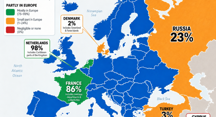
When we look at a map of Europe, it seems simple:
Europe is a continent made up of European countries.
But geography is not always that straightforward.
Some countries are entirely inside Europe.
Others stretch across multiple continents.
A few countries are politically connected to Europe but geographically located partly or completely outside it.
This creates a fascinating question:
What percentage of each country’s land is actually located in Europe?
Europe Is Not Only About Politics
A common mistake is assuming that membership in European organizations determines geography.
For example:
- A country can be part of European political institutions but have territory outside Europe.
- A country can physically have land in Europe and Asia at the same time.
Geography is based on physical location, while politics is based on borders, alliances and history.
This map focuses on:
The percentage of each sovereign country’s land area physically located in Europe.
Countries 100% Located in Europe
Most European countries are completely located within the continent.
These include:
- Germany
- Spain
- Italy
- Poland
- Portugal
- Greece
- Sweden
- Norway
- Finland
- Ireland
- Austria
- Switzerland
For these countries:
100% of their land area is in Europe.
Their borders fall entirely within the traditional geographic boundaries of Europe.
Russia: The Largest Country With a Small European Share
Russia is the most dramatic example of a country spanning continents.
Russia stretches across:
- Eastern Europe
- Northern Asia
The European part of Russia contains many important cities, including:
- Moscow
- Saint Petersburg
- Nizhny Novgorod
However, most of Russia’s land is located in Asia.
According to the map:
About 23% of Russia’s land area is in Europe.
Even though the European portion is much smaller than the Asian portion, it contains a large share of Russia’s population and history.
Turkey: A Country Between Europe and Asia
Turkey is another famous transcontinental country.
Its territory is divided between:
European Turkey
Known as:
East Thrace
Located west of the Bosporus Strait.
Asian Turkey
Known as:
Anatolia
The much larger part of the country.
Only about:
3% of Turkey’s land area is in Europe.
However, the European part includes Istanbul’s western side, one of the world’s most important cities.
Istanbul itself sits across two continents:
- Europe
- Asia
France: The Overseas Territory Question
France creates an interesting geographic situation.
Metropolitan France is entirely in Europe.
However, France also controls overseas territories around the world, including:
- Caribbean islands
- Indian Ocean territories
- Pacific territories
When overseas territories are included in the country’s total land area, the percentage located in Europe decreases.
The map shows:
France: about 86% in Europe
This depends on whether overseas territories are counted.
The Netherlands: Almost Entirely European, But Not Completely
The Netherlands is mostly European.
However, the Kingdom of the Netherlands also includes Caribbean territories such as:
- Aruba
- Curaçao
- Sint Maarten
- Bonaire
- Sint Eustatius
- Saba
Because of these territories:
The Netherlands is shown as about 98% European.
The European Netherlands is the mainland country most people recognize, but the kingdom extends far beyond Europe.
Denmark: The Greenland Effect
Denmark is another unusual case.
The Kingdom of Denmark includes:
- Denmark proper
- Greenland
- Faroe Islands
Greenland is geographically part of North America, not Europe.
Because Greenland is enormous, it dramatically changes Denmark’s percentage.
The map shows:
Denmark: about 2% in Europe
This does not mean Denmark itself is mostly outside Europe.
It means the entire Kingdom of Denmark includes a massive Arctic territory.
Cyprus: Politically European, Geographically Asian
Cyprus is one of the most debated examples.
Politically:
- Cyprus is a member of the European Union.
Geographically:
- The island is located in West Asia.
The map classifies:
Cyprus: 0% physically in Europe
This shows the difference between:
- Political Europe
- Geographic Europe
Both concepts can be different.
Countries Mostly in Europe
Some countries have small territories outside Europe but are still overwhelmingly European.
Examples:
France
≈ 86%
Because of overseas territories.
Netherlands
≈ 98%
Because of Caribbean territories.
Other countries may have minor overseas possessions or special territories.
Why Do Borders Become Complicated?
The reason is history.
Modern countries were not created based only on continents.
They developed through:
- Empires
- Colonization
- Exploration
- Wars
- Treaties
- Political unions
A European country today may still have territories thousands of kilometers away because of historical connections.
Europe’s Geographic Boundary Is Debated
Even the border between Europe and Asia is not universally simple.
The traditional boundary usually follows:
- Ural Mountains
- Ural River
- Caspian Sea
- Caucasus region
- Black Sea
- Turkish Straits
But different geographic traditions define the boundary slightly differently.
This is why countries like:
- Russia
- Turkey
- Georgia
- Kazakhstan
are often described as transcontinental or culturally connected to both regions.
Geography vs Identity
A map can show physical location, but countries are more than coordinates.
A country may identify strongly with Europe because of:
- History
- Culture
- Politics
- Economy
Even when some territory lies outside the continent.
Likewise, a country may have European territory but a broader identity connecting multiple regions.
The Biggest Lessons From This Map
This map reveals several surprising facts:
1. A country is not always located in only one continent
Russia, Turkey and Denmark show how borders can cross continental boundaries.
2. Political Europe and geographic Europe are different
Membership and identity do not always match physical geography.
3. History shapes modern maps
Overseas territories and historical relationships still influence where countries exist today.
Final Thought
A world map often makes countries look simple.
But behind every border is a complicated story of geography, history and politics.
Europe is not just a collection of countries inside one clear boundary.
It is a continent shaped by centuries of movement, empire and connection.
The next time you look at a map of Europe, remember:
A country’s location is not always as simple as the color covering it.
Sources:
Sovereign land-area references; conventional Europe geographic boundaries; international geographic classifications.