
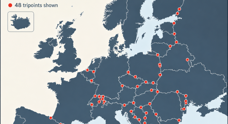
Most international borders separate two countries.
But scattered across Europe are unusual places where three countries meet at exactly the same location.
These places are known as international tripoints.
Some sit on remote mountain summits. Others are hidden in rivers or lakes. A few have elaborate monuments where visitors can walk around and seemingly step through three countries within seconds.
According to the border-reference site Barry’s Borderpoints, Europe has 48 international tripoints, although the precise count can depend on how disputed borders and unusual boundary arrangements are treated.
Together, they reveal a fascinating side of European geography that ordinary political maps rarely show.
What Is a Tripoint?
A tripoint—also called a trijunction—is a geographical point where the borders of three countries meet.
Imagine three neighboring countries:
Country A | Country B | Country C
Normally, each pair shares its own border. Eventually those three boundaries may converge at one point.
That intersection is the tripoint.
Standing at the right spot could theoretically allow a person to place one foot in one country, another foot in a second, and reach into a third.
But not every tripoint is so easy to visit.
Some are in the middle of rivers.
Others are high in the Alps.
Several lie along sensitive international borders where tourists cannot simply walk around freely.
Europe Has About 48 International Tripoints
Barry’s Borderpoints catalogs 48 European tripoints.
They are divided into three broad geographical types:
- 26 dry tripoints on land
- 19 wet tripoints located in rivers or lakes
- 3 mixed or complex tripoints involving both land and water boundary arrangements
That means nearly half of Europe’s tripoints have some connection with water.
This makes sense historically.
European borders frequently follow rivers because waterways provide obvious natural boundaries.
Where several river borders converge, a tripoint can appear naturally.
Why Are There So Many in Central Europe?
Look closely at the map and one feature immediately stands out.
Tripoints are particularly concentrated across Central Europe and the Balkans.
Countries such as Austria, Switzerland, Hungary, Slovakia, Slovenia, Croatia and their neighbors are packed closely together.
Austria alone borders eight countries.
Switzerland borders five.
Hungary borders seven.
Serbia borders numerous neighboring states depending on how Kosovo is counted.
When many relatively small countries share a compact region, the number of places where three borders intersect naturally increases.
Western Europe has another cluster around Belgium, Luxembourg, Germany, France and the Netherlands.
By contrast, isolated island countries such as Iceland, Ireland and the United Kingdom have no international land tripoints.
Finland, Norway and Sweden: The Famous Three-Country Cairn
One of Europe’s best-known tripoints lies in the far north, where Finland, Norway and Sweden meet.
The location is marked by the Three-Country Cairn, a large concrete monument sitting in Lake Goldajärvi.
A walkway allows visitors to reach the monument.
Walk around it and you can effectively pass through Finland, Norway and Sweden within seconds.
The current monument dates from 1926.
It has become something of a geographical tourist attraction precisely because very few international borders allow visitors to experience three countries so easily.
Finland, Norway and Russia: Three Countries—and Three Time Zones
Travel farther east and another remarkable Nordic tripoint appears.
This one joins:
Finland
Norway
Russia
It is marked by a cairn known as Treriksrøysa, or the Three-Country Cairn.
But its most unusual feature isn’t merely the three borders.
According to Barry’s Borderpoints, it is the only European tripoint where three time zones meet.
That makes it one of the continent’s strangest combinations of political and temporal geography.
Unlike the Finland–Norway–Sweden point, however, its proximity to Russia makes access considerably more sensitive.
Belgium, Germany and the Netherlands: One of the Easiest to Visit
Not every tripoint requires hiking through wilderness.
The meeting point of Belgium, Germany and the Netherlands is one of Europe’s most accessible.
It is situated near Vaalserberg, the highest point of the European Netherlands.
The surrounding area has observation facilities, restaurants and tourist attractions.
This makes it possible to visit three countries during what is essentially an ordinary afternoon excursion.
Long before Europe’s modern open-border arrangements, such a place represented three very distinct national frontiers.
Today, because Belgium, Germany and the Netherlands are within the Schengen Area, the border can feel almost invisible.
The geography hasn’t changed.
The experience of crossing it has.
Austria, Hungary and Slovakia
Near the villages of Čunovo in Slovakia, Rajka in Hungary and Deutsch Jahrndorf in Austria lies another highly symbolic tripoint.
A border pillar marks where Austria, Hungary and Slovakia meet.
Today visitors can see sculptures, signs and border markers from all three countries.
This region has experienced enormous political change.
During the Cold War, Austria stood outside the Eastern Bloc while Hungary and Czechoslovakia lay on the other side of the Iron Curtain.
Today all three states are members of the European Union, and the once heavily political frontier has become dramatically easier to cross.
A simple border monument therefore tells a much larger story about modern European history.
Austria, Italy and Slovenia: Three Cultures on One Mountain
At approximately 1,509 meters above sea level, another tripoint joins:
Austria
Italy
Slovenia
The point lies on Peč Mountain.
It is known by different names in the three neighboring languages, including Tromeja and Dreiländereck.
The meeting point has become a symbol of cooperation between communities that were historically separated by shifting national frontiers.
A substantial border stone marks the location.
The tripoint is particularly interesting because it sits where Germanic, Romance and Slavic cultural regions come together.
Few places demonstrate Europe’s linguistic diversity so neatly.
France, Italy and Switzerland: One of the Hardest Tripoints to Reach
Some tripoints are tourist attractions.
The France–Italy–Switzerland meeting area is considerably more serious.
It lies in the high Alps near Mont Dolent.
Barry’s Borderpoints describes it as physically the hardest European tripoint to reach.
Reaching the area can involve a two-day mountain journey, glacier travel, ice, ropes and appropriate mountaineering experience.
A guide may be advisable.
The actual boundary junction is on the high ridge rather than conveniently beside a road or walking path.
It demonstrates just how arbitrary a simple red dot can appear on a map.
On paper, it is merely one coordinate.
On the ground, it can be surrounded by rock, snow, ice and thousands of meters of mountain terrain.
Albania, Greece and North Macedonia: A Tripoint in a Lake
Some tripoints cannot be stood on at all.
The boundary between Albania, Greece and North Macedonia meets in Lake Prespa.
The point sits in the water, roughly southwest of Golem Island.
It is therefore classified as a wet tripoint.
Wet tripoints are surprisingly common in Europe because lakes and rivers frequently form international boundaries.
The precise border may exist mathematically in the middle of the water even though there is no visible line on the surface.
Bulgaria, Greece and Turkey: A Sensitive Frontier
The point where Bulgaria, Greece and Turkey meet is very different from the open-border tripoints of Western Europe.
It lies near the Maritsa River in a secure border area.
According to Barry’s Borderpoints, reaching the location is difficult to arrange, and border infrastructure limits access around the monument.
This highlights another important fact:
A tripoint may be geographically interesting without being a tourist destination.
Border laws always matter.
Walking casually around some European tripoints could involve entering another country’s territory outside an authorized crossing.
Czechia, Germany and Poland
The Czechia–Germany–Poland tripoint lies where waterways meet near the cities and towns of Hrádek nad Nisou, Zittau and Bogatynia.
The exact point is in the water.
Large border markers and monuments stand nearby in each country.
There have even been ideas for a three-way bridge that would symbolically link the countries at the boundary.
It is another example of an old national frontier becoming a place of tourism and international cooperation.
Czechia, Poland and Slovakia
Another particularly interesting tripoint joins Czechia, Poland and Slovakia.
Here the exact intersection occurs where two streams meet.
A monument marks the location beneath a bridge spanning part of the border area.
Walkways, signs and national symbols give the surrounding area the feel of a small international park rather than a remote frontier.
This is one of the easiest ways to visualize what a tripoint actually represents.
Three separate political territories converge within an extremely small physical space.
Poland, Slovakia and Ukraine
Farther east, Poland, Slovakia and Ukraine meet in the Carpathian region at Kremenec.
The location is approximately 1,221 meters above sea level.
A three-sided marble monument identifies the tripoint.
It is also geographically significant for Slovakia because the location marks the country’s easternmost point.
Hiking trails approach it from the Slovak side.
Political circumstances, however, mean that conditions and border-access rules should always be checked before attempting to visit tripoints involving Ukraine.
Lithuania, Poland and Russia
One of Europe’s most geopolitically sensitive tripoints is where Lithuania, Poland and Russia meet.
The Russian territory here is not connected by land to the rest of Russia.
It is the Kaliningrad exclave, positioned between Poland and Lithuania on the Baltic Sea.
A granite monument was installed at the tripoint in 2010.
The location became even more sensitive following Russia’s invasion of Ukraine, and Barry’s Borderpoints notes additional fortification separating the Russian section by 2024.
This is an excellent example of how the physical coordinates of a border can remain unchanged while its political significance changes dramatically.
Moldova, Romania and Ukraine Meet Twice
One fascinating feature of tripoint geography is that the same three countries can meet more than once.
Moldova, Romania and Ukraine have two separate tripoints.
The northern tripoint lies in the Prut River.
The southern tripoint lies in the Danube near the point where the Prut reaches it.
The southern location is also near Giurgiulești, Moldova’s small but strategically important access to the Danube.
Both are classified as wet tripoints.
Andorra Creates Two Tripoints
Another unusual case involves tiny Andorra.
Because Andorra sits between France and Spain, the three countries meet at both ends of the Andorran border.
That creates two separate France–Spain–Andorra tripoints.
One lies around the Portella Blanca d’Andorra area, while the western point is located high on Pic de Médécourbe, at roughly 2,914 meters.
So although only three countries are involved, geography produces two separate places where all three meet.
Liechtenstein Does the Same Thing
The shape and position of Liechtenstein create another pair.
Austria, Liechtenstein and Switzerland meet once in the north and again in the south.
The northern junction lies in the Rhine.
The southern one is on Naafkopf, a mountain in the Rätikon Alps.
One set of three countries therefore produces both a wet tripoint and a mountain tripoint.
One “Tripoint” Isn’t Even Clearly Agreed Upon
Perhaps Europe’s strangest example involves Germany, Austria and Switzerland in Lake Constance.
You might expect cartographers to be able to identify an exact point where the three countries meet.
The problem is that the countries have historically had different interpretations of how sovereignty over parts of Lake Constance should be divided.
As a result, the exact international division of the lake has never been settled in the simple way most land borders are.
Practical questions such as fishing and navigation have been handled through agreements, so daily life continues without needing a perfectly agreed line across every part of the lake.
It is a wonderful reminder that political borders are human agreements—not natural lines physically drawn across the Earth.
Some Tripoints Are Disputed
The neat dots on the map can also hide political disagreements.
For example, the precise Croatia–Hungary–Serbia junction is affected by the unresolved Croatia–Serbia border dispute along parts of the Danube.
Serbia generally favors a river-based boundary interpretation, while Croatia relies on historical cadastral boundaries in disputed sections.
Kosovo adds another complication.
Tripoints involving Kosovo may be counted differently depending on a source’s treatment of Kosovo’s political status and international recognition.
That is why 48 should be understood as the count used by the map’s source rather than an unquestionable mathematical constant.
Tripoints Can Appear—and Disappear
International tripoints are not permanent geological features.
They exist because countries and borders exist.
When political borders change, tripoints can change as well.
The breakup of Czechoslovakia in 1993, for example, created new boundaries for the Czech Republic and Slovakia.
The collapse of Yugoslavia produced multiple new international borders across the Balkans.
The collapse of the Soviet Union transformed internal Soviet administrative boundaries into international frontiers between newly independent countries.
Barry’s Borderpoints consequently also records historical tripoints that no longer function as international meeting points.
Why Western Europe Has So Many Accessible Tripoints
The creation of the Schengen Area completely changed the experience of visiting many European borders.
At numerous tripoints within Schengen, there may be no immigration checkpoint at all.
A traveler can hike from one country into another and sometimes walk around a border monument without showing a passport.
Historically, these same boundaries could involve customs posts, checkpoints and heavily controlled crossings.
So a peaceful three-country monument today can stand in a place that once represented a very real political barrier.
Why Islands Don’t Have International Tripoints
The map also explains why countries such as Iceland appear far away from the red-dot clusters.
An island containing only one sovereign country cannot have a conventional land tripoint because it has no neighboring land borders.
The same applies to Ireland unless the definition were to involve maritime boundaries; the island contains only one international land border, between Ireland and the United Kingdom, so there is nowhere for a third country to join it.
Tripoints therefore tell us something about the shape and neighborhood structure of countries, not just their number.
Can You Really Stand in Three Countries at Once?
Sometimes.
At an accessible dry tripoint, a person may genuinely be able to position themselves across three national territories.
At wet tripoints, the true coordinate may sit several meters into a river or lake.
At others, a monument may be placed close to the actual mathematical boundary rather than directly on it.
And some locations are inaccessible because of:
- Mountains
- Rivers
- Border fences
- Military restrictions
- Protected environments
- Visa requirements
- Political disputes
So the answer depends entirely on the tripoint.
A Map of European History Hidden in 48 Dots
The 48 red dots on this map may look small, but each represents the meeting of three different political territories.
Some were shaped by medieval kingdoms.
Others were created after the world wars.
Several appeared only after the collapse of the Soviet Union, Yugoslavia or Czechoslovakia.
Some now sit inside peaceful open-border regions.
Others remain among Europe’s most sensitive frontiers.
That makes tripoints far more than geographical curiosities.
They are tiny points where geography, politics and history all intersect at exactly the same place.
And in a few of them, you really can walk around a stone and visit three countries in less than a minute.
Source Note
The map uses Barry’s Borderpoints’ catalog of European tripoints, which lists 48 locations. That source currently classifies 26 as dry, 19 as wet and 3 as mixed. Counts can vary depending on disputed borders, political recognition and unusual boundary arrangements such as Lake Constance.