In 1920, Europe was still trying to understand what had just happened to it.
World War I had killed millions.
The Austro-Hungarian Empire had disappeared.
The German Empire had fallen.
The Ottoman Empire was breaking apart.
New states appeared across Central and Eastern Europe, while borders were being redrawn through treaties signed by victorious and defeated powers.
Nationalism had helped create new countries.
But one anonymous writer in Vienna believed nationalism itself was the problem.
His solution was extraordinary:
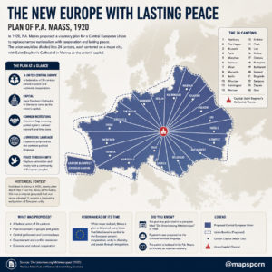
Erase most of Central Europe’s existing national borders and replace them with one enormous federation divided into 24 wedge-shaped cantons.
France, Germany, Poland, Austria, Hungary, the Netherlands, Belgium, Switzerland and much of Central and Eastern Europe would cease to exist in anything resembling their familiar political forms.
Instead, straight-looking cantonal zones would radiate outward from a new common capital near Vienna.
The proposal even imagined a common currency, common postal system, common time zone and eventually a common language.
At first glance, it can look strangely futuristic.
But read the original 1920 pamphlet closely and the plan becomes much stranger—and much more troubling—than a simple “European Union before the EU.”
The Map Came From the Chaos After World War I
The proposal appeared in Vienna in 1920 under the German title:
Die Unionisierung Mitteleuropas! Ein Wegweiser zum Dauerfrieden
roughly:
“The Unionization of Central Europe: A Guide to Lasting Peace.”
It was accompanied by an elaborate map titled “The New Europe with Lasting Peace.”
Cornell University describes it as a utopian plan for a radically restructured Europe after World War I. German History in Documents and Images notes that the author was deeply dissatisfied with the peace settlement after the war, particularly the treaties imposed on the defeated Central Powers. (German History in Documents and Images)
The author believed the new system of nation-states would not eliminate rivalry.
Quite the opposite.
In his view, the postwar borders would simply create new grievances and eventually another conflict.
His proposed cure was not to redraw national boundaries more carefully.
It was to make those national boundaries largely irrelevant.
One Giant State Instead of Rival Nations
The proposed state would cover a huge portion of continental Europe.
Its boundaries would stretch from France and the Low Countries through Germany, Switzerland, Austria and Hungary, deep into what are today Poland, Ukraine, Romania and the Balkans.
It did not include all of Europe.
Britain and Scandinavia remained outside, as did Iberia, much of southern Italy and several southeastern territories.
But the proposed union would still have been an enormous multinational state occupying much of Europe’s political and economic center. Cornell describes it as a “pie” of 24 cantons whose boundaries radiated from the center with little respect for existing linguistic or cultural borders. (Illinois Digital Library)
That was deliberate.
The author believed national separation caused conflict.
So rather than giving Germans, Poles, Hungarians, French speakers or Slavs their own coherent territories, he wanted populations deliberately mixed together.
Europe Would Be Divided Into 24 Cantons
The new union would contain 24 cantons, each named for an important city.
In the original 1920 terminology they were Paris, Brussels, The Hague, Hamburg, Berlin, Breslau, Königsberg, Warsaw, Kraków, Pinsk, Lemberg, Kaschau, Odessa, Budapest, Szeged, Bucharest, Belgrade, Sarajevo, Zagreb, Graz, Marseille, Milan, Geneva and Munich. (Wikisource)
Several names look different today because borders and city names changed.
Breslau is now Wrocław in Poland.
Königsberg is now Kaliningrad in Russia.
Lemberg is now Lviv in Ukraine.
Kaschau is Košice in Slovakia.
The cantons were not supposed to resemble modern states.
Instead, their boundaries radiated outward from the center of the union.
The map makes them look almost like slices of a giant pie.
The Straight Lines Were More Symbolic Than Literal
The original map shows remarkably straight cantonal boundaries.
That gives the proposal its unforgettable appearance.
But the author acknowledged that the real borders would not necessarily be perfectly straight.
He proposed that they follow existing municipal and town boundaries where practical while staying close to the radial lines shown on the map. Deviations of more than about five kilometers were to be avoided. (Wikisource)
The intention was still radical.
Traditional historical boundaries would cease to matter.
Alsace-Lorraine would no longer be something France and Germany could fight over.
Disputes involving Posen, Trentino and other mixed regions were supposed to disappear because the entire national-border framework would be dismantled. (Wikisource)
In the author’s theory, if countries no longer existed in their traditional form, they could no longer fight over disputed provinces.
The Center of Everything Would Be “St. Stephan”
This is where the infographic needs its biggest correction.
The plan did not simply make St. Stephen’s Cathedral in central Vienna the political capital.
Instead, it proposed constructing an enormous new federal capital called St. Stephan.
The author imagined it as a vast garden city incorporating territory around Vienna, the Danube, parts of what is now eastern Austria and even areas extending toward present-day Slovakia and Lake Neusiedl.
The 24 cantons would converge there. (Wikisource)
Its design was extraordinarily ambitious.
A huge ring road would surround the capital.
Twenty-four monumental gates would correspond to the 24 cantons.
Railways and tramways would enter through those gates.
Roads would point toward a central monument celebrating the foundation of the union.
The author even cited Karlsruhe, famous for its radial street plan, as a model for the new capital. (Wikisource)
This was urban planning on an almost science-fiction scale for 1920.
The Capital Was Supposed to Be a Garden City
The author wanted St. Stephan to be spacious, hygienic and green.
Buildings would be restricted in height.
Large gardens would separate houses.
Schools would have outdoor recreation spaces.
Heavy industry producing excessive smoke, odor or noise would eventually be moved away from the capital.
Airfields, railways, ports and other modern infrastructure would connect the city to the rest of the union. (Wikisource)
Even part of Lake Neusiedl was imagined as a recreation district built in a Venetian style.
The proposal therefore was not merely about changing borders.
It attempted to design an entirely new political civilization from the ground up.
Esperanto Would Eventually Become the Common Language
One of the plan’s most unusual ideas was the adoption of Esperanto.
The author believed linguistic differences contributed to national division.
His solution was gradual linguistic unification.
Teachers would first be required to learn Esperanto.
Schools would devote enormous amounts of teaching time to it.
After roughly 25 years, Esperanto would become the common command language of the armed forces.
After around another 20 years, it would become the state language of the union. (Wikisource)
The plan even envisioned a later referendum on whether traditional mother tongues should continue being taught.
This goes far beyond the multilingual model used by today’s European institutions.
The ultimate goal was not simply communication between different cultures.
It was gradual linguistic convergence.
One Time Zone for the Entire Union
Language was not the only thing the author wanted standardized.
Western, Central and Eastern European time would be abolished within the union.
The whole territory would use one time based on the new capital of St. Stephan. (Wikisource)
That would mean people from France to eastern Europe sharing one official clock.
Today Europe still spans multiple time zones.
The 1920 scheme was therefore, in some respects, more centralized than contemporary Europe.
A Common Flag, Postage and Currency
The union would also have one national flag.
The original map actually showed proposed flag designs.
One side featured four hands symbolizing the four major population groups recognized by the project.
Postal stamps and other official documents would carry union symbols.
A single monetary system would replace the different national currencies. (Wikisource)
And the chosen currency was surprisingly not a new European name.
The author proposed using the:
Dollar.
Banknotes would be issued in denominations ranging from 1 to 10,000, and larger notes were eventually supposed to carry portraits of the union’s first presidents. (Wikisource)
So the map’s claim that the plan contained elements resembling later European integration—common institutions, internal trade and a common currency—is fair at a very broad level.
But the similarities should not be pushed too far.
The Government Would Rotate Between Four “Nations”
The author divided the union’s population into only four officially recognized broad categories:
Romance peoples, Germanic peoples, Slavic peoples and Magyars.
These categories would play a formal role in government.
The union president would serve a three-year term, with the presidency rotating among the four groups.
The first president was supposed to be French, followed by a Prussian German, then a Pole, then a Magyar.
Future cycles would rotate through other subgroups. (Wikisource)
The cabinet would also be distributed among these categories.
The author apparently hoped that rotating power would prevent one national group from permanently dominating the federation.
It was a form of engineered power-sharing—but based on sweeping ethnic classifications that would be considered crude and exclusionary today.
The Voting System Was Far From Modern Democracy
This is another important part that the infographic leaves out.
The proposal did provide voting rights to some women, which might sound progressive for 1920.
But married women would not be allowed to vote.
The author argued that a husband could represent his wife’s political views.
Only unmarried women and widows meeting the necessary conditions would vote independently. Candidates for office were restricted to men. (Wikisource)
So while the plan presented itself as a peaceful future society, its democratic institutions were profoundly unequal by modern standards.
Peace Was Supposed to Come With a Two-Million-Man Army
The phrase “lasting peace” might suggest demilitarization.
Not exactly.
The proposed union would initially maintain four national armies, corresponding to Romance, Germanic, Slavic and Magyar populations.
The author estimated a standing land force of roughly two million men, including forces in the union and its colonies. (Wikisource)
Military service was compulsory.
A man’s service obligations would begin around age 21 and extend into reserve status until his early 40s.
Part of the service would involve military duty; another portion would involve state labor on projects such as roads, railways, canals, industrial works and flood control. (Wikisource)
Eventually, once Esperanto had become widespread, the four national armies were supposed to merge into one unified force.
So this was very much a heavily organized state, not a loose voluntary association.
Some Parts of the Plan Were Explicitly Coercive
This is why describing the project simply as a “vision ahead of its time” is misleading.
The author wanted to eliminate national rivalry partly through deliberate demographic mixing.
In some frontier areas, soldiers from different ethnic groups would be settled among local populations.
Unmarried settlers were expected to enter mixed-nationality marriages.
Existing residents in certain border regions were also expected to accept intermarriage or eventually exchange their land and move elsewhere. (Wikisource)
The document also contained openly discriminatory ideas toward Roma people, including proposals for state intervention in families and expulsion of adults who resisted the system. (Wikisource)
These are not minor details.
They show that the author’s proposed route toward “unity” often meant enforced assimilation rather than modern pluralism.
The Union Would Still Have Colonies
Perhaps the greatest contradiction in the project is its attitude toward empire.
The author presented the plan as a way to overcome European nationalism and create lasting peace.
Yet he had no intention of abandoning European colonialism.
Instead, he proposed combining and exchanging colonial territories among European powers.
The union itself would possess large colonial holdings and use them to obtain raw materials.
The pamphlet imagined territorial swaps involving British, French, Dutch, Portuguese, Spanish and Italian possessions in Africa and elsewhere. (Wikisource)
In other words, the proposal tried to eliminate certain rivalries inside Europe while preserving imperial domination outside Europe.
That places it firmly within the political assumptions of its time.
The Original Plan Was Much Stranger Than the Modern Infographic
The clean modern map makes the project look almost familiar:
European integration.
Twenty-four regions.
Common institutions.
A common currency.
Peace through cooperation.
But the original document also proposed a huge military, colonial empire, ethnic engineering, discriminatory voting rules, a gradually imposed common language and forced demographic mixing.
That makes it less like the European Union and more like a uniquely 1920s utopian attempt to engineer society from above.
Its mixture of idealism and authoritarianism is precisely what makes the document so historically fascinating.
Was It an Early European Union?
Only in the broadest sense.
There were many ideas for European federation before the modern EU.
This 1920 proposal certainly shared some themes that would later become important: reducing conflict through integration, eliminating some economic barriers and placing previously rival populations within common institutions.
But there is no basis for treating P.A.M.’s scheme as a direct blueprint for today’s EU.
The historical institutional path to the EU is normally traced through the post–World War II integration process, particularly Robert Schuman’s 1950 proposal to pool French and West German coal and steel production and the creation of the European Coal and Steel Community in 1951. (European Union)
And the philosophical difference is enormous.
The EU developed by cooperation among continuing sovereign states.
The 1920 plan proposed largely wiping existing states off the map and redesigning their populations and territories.
The Timing Is What Makes the Map So Interesting
The document was published only about two years after World War I ended.
Europe’s political order genuinely appeared unstable.
The Austro-Hungarian Empire had vanished.
Poland had returned to the map.
Czechoslovakia and Yugoslavia had appeared.
Austria and Hungary had become separate states.
Germany had lost territory.
Borders through Central and Eastern Europe remained controversial.
The author looked at this fragmented postwar map and decided the answer was not more precise nationalism.
It was the opposite:
Destroy the political structure of nationalism altogether.
His solution was unrealistic and often deeply coercive, but his diagnosis—that unresolved rivalries could lead Europe toward another catastrophe—was ominously relevant.
Only nineteen years later, Europe entered World War II.
The Mysterious Author
The pamphlet was signed simply:
P.A.M.
The author explained that his true identity and profession had been deposited with a notary and would be revealed only after the major peoples of the proposed union publicly reacted to his plan. (Wikisource)
Modern archives do not agree completely on the identification.
Cornell’s Persuasive Cartography collection identifies the creator as P. A. Maas and notes that he was likely connected with Otto Maaß’ publishing firm, which printed the work. German History in Documents and Images likewise describes P.A. Maas as the likely author. (German History in Documents and Images)
Because the original work intentionally used initials, the safest wording is:
“P.A.M., commonly attributed to P. A. Maas.”
That is more accurate than presenting the identity as completely certain.
Why Was the Plan Never Adopted?
There was never a realistic political path to implementing it.
Its proposal required states from France to Eastern Europe to voluntarily abolish or surrender enormous parts of their sovereignty.
Governments would have had to abandon historic frontiers.
Populations would have been reorganized into unfamiliar cantons.
Major powers would have needed to exchange colonies.
Existing political institutions would disappear.
National languages would eventually lose official primacy.
Even in the political chaos of 1920, that was an extraordinary ask.
The project remained what Cornell calls a utopian scheme, preserved today mainly as a fascinating piece of persuasive cartography. (Cornell Digital Library)
A Map of Hope—and the Problems of Its Era
More than a century later, the map is fascinating precisely because it contains two very different visions at once.
One is strikingly idealistic.
It imagines former enemies sharing institutions, trade, infrastructure and government instead of repeatedly fighting over borders.
The other is unmistakably rooted in the prejudices and authoritarian thinking of the early 20th century.
Peace would sometimes be imposed.
Cultures would be intentionally merged.
Political rights would not be equal.
Colonial rule would continue.
And enormous state power would be used to reshape society.
So the map should not be remembered simply as:
“Someone invented the EU in 1920.”
A better description is:
In the wreckage of World War I, an anonymous Viennese visionary tried to redesign most of Central Europe from scratch—and produced one of the strangest political maps of the 20th century.
Source and Accuracy Note
The original source is Die Unionisierung Mitteleuropas! Ein Wegweiser zum Dauerfrieden, published in Vienna in 1920 and signed P.A.M. The accompanying historical map survives in Cornell University’s P.J. Mode Collection of Persuasive Cartography and other archives. The original scheme divided the proposed union into 24 cantons, envisaged a new capital named St. Stephan around the Vienna region, proposed Esperanto as an eventual common state language, envisioned common money and institutions, and also contained coercive, discriminatory and colonial provisions. It was never adopted. (Wikisource)