Switzerland looks small on a map.
Its total area is only about 41,000 square kilometers, smaller than many individual states or provinces elsewhere in the world.
Yet squeezing Switzerland into one simple national description is surprisingly difficult.
It has four national languages.
Twenty-six cantons.
Mountain valleys that historically developed distinct cultures.
Cities where neighboring districts may speak different dialects.
School calendars that change when you cross a cantonal border.
And a political system built around giving local governments unusually strong powers.
That is why Switzerland often makes more sense when viewed not as one perfectly uniform country, but as a federation of regions with strong individual identities.
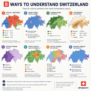
The eight maps above try to show that idea from several angles.
Some are serious geography.
Some concern laws.
Others are cultural generalizations.
Together, they reveal why Switzerland can feel remarkably different from one valley, canton or language region to the next.
1. Switzerland Really Is a Multilingual Country
Perhaps the first thing to understand about Switzerland is that there is no single “Swiss language.”
The country recognizes four national languages:
German
French
Italian
and
Romansh.
At the federal level, German, French and Italian are fully official languages, while Romansh is also used officially when the federal government communicates with Romansh speakers. (About Switzerland)
The latest Federal Statistical Office figures for main languages are approximately:
German — 61%
French — 23%
Italian — 8%
Romansh — 0.4%. (BFS Dam API)
These percentages do not represent every language spoken in Switzerland.
English, Albanian, Portuguese, Spanish, Serbian, Croatian and many other languages are common because of immigration, and 16% of residents report two or more main languages. (BFS Dam API)
The Language Border Is Visible
Western Switzerland is predominantly French-speaking.
The central, northern and eastern portions are overwhelmingly German-speaking.
Italian dominates in Ticino and parts of Graubünden.
Romansh survives mainly in parts of Graubünden.
Four cantons are officially multilingual: Bern, Fribourg, Valais and Graubünden. Graubünden is especially remarkable because German, Italian and Romansh all have an official presence there. (About Switzerland)
Some cities even have two official names.
Biel/Bienne, for example, reflects its German- and French-speaking communities directly in its name.
Swiss German Adds Another Layer
Even the phrase “German-speaking Switzerland” hides enormous diversity.
Most German-speaking Swiss use Swiss German dialects in everyday conversation rather than Standard German.
And those dialects differ noticeably between Basel, Bern, Zurich and other regions. (About Switzerland)
So someone traveling across Switzerland can cross multiple linguistic boundaries without ever leaving the country.
2. Yes, Switzerland Had a Famous Naked-Hiking Debate
This sounds like the joke panel.
It is actually based on a real legal controversy.
During the late 2000s, nude hiking became surprisingly prominent in parts of northeastern Switzerland.
Residents in Appenzell complained about hikers walking through rural areas completely naked.
In 2009, the small canton of Appenzell Innerrhoden moved to prohibit naked hiking and impose fines. (SWI swissinfo.ch)
Neighboring Appenzell Ausserrhoden did not initially have the same specific ban, but a higher court later upheld a fine against a nude hiker under public-decency provisions. (SWI swissinfo.ch)
So the real rule is more complicated than:
“Naked hiking is legal everywhere except one canton.”
Switzerland’s decentralized system means cantonal and local rules matter, and behavior can also fall under broader public-decency laws.
The better takeaway is:
Switzerland genuinely had a legal battle over naked hiking—and the answer differed depending on where you were hiking.
Which is a very Swiss story.
3. Beer, Wine and the Geography of Swiss Drinking
The infographic divides Switzerland into supposed beer and wine regions.
There is some cultural logic behind this.
Wine production is deeply associated with areas such as:
Valais,
Vaud,
Geneva,
Ticino
and parts of Neuchâtel.
Beer has historically been prominent across much of German-speaking Switzerland.
But I would be careful presenting a precise “favorite drink by canton” map as official fact.
Federal statistics for 2022 show that nationally about:
49% of people drank wine at least weekly
while
38% drank beer at least weekly. (SwissStats)
Age and sex produce major differences too.
Younger adults tend to favor beer more than older adults, while wine consumption becomes more common with age. (SwissStats)
So demographic differences may sometimes be stronger than regional ones.
And What About Absinthe?
The map highlights the Val-de-Travers area of Neuchâtel.
That part is absolutely culturally important.
Val-de-Travers is historically famous as one of the homes of absinthe.
The geographical name “Absinthe du Val-de-Travers” has appeared in Swiss international geographical-indication protection arrangements, although as of the latest Federal Office for Agriculture register information, an application for Swiss PGI/GGA registration was still being processed. (IGE)
So I would describe absinthe as:
a famous regional specialty
rather than claiming it is necessarily the population’s “favorite drink.”
4. Mountains Explain an Enormous Amount About Switzerland
This is one of the infographic’s strongest panels.
Switzerland can be divided into three major geographical regions:
The Alps — roughly 58–60%
The Central Plateau — around 31%
The Jura — around 11%. (About Switzerland)
Approximately 70% of Swiss territory is mountainous, yet only about a quarter of the population lives in mountain regions. (About Switzerland)
That produces an unusual demographic geography.
The country looks mountainous almost everywhere on a physical map.
But most Swiss people live in a relatively narrow lower-elevation corridor.
The Central Plateau Is Where Switzerland Crowds Together
The Central Plateau stretches roughly from Lake Geneva toward Lake Constance.
It occupies only around 30% of national territory but contains more than two-thirds of the population. (About Switzerland)
This is where many major population centers are found:
Zurich,
Geneva,
Bern,
Lausanne
and surrounding urban regions.
In 2026, Switzerland’s population density was about 226 people per square kilometer nationally, but the Central Plateau approached 600 per square kilometer. (About Switzerland)
That contrast helps explain several other Swiss maps.
Traffic?
Mostly concentrated here.
Housing pressure?
Mostly here.
Rail networks?
Densest here.
Industry?
Again, heavily concentrated on the Plateau.
Switzerland’s physical geography strongly shapes everyday life.
5. “What Does the Rest of Switzerland Think About Zurich?”
This is where the infographic becomes intentionally playful.
Zurich is Switzerland’s largest city and its most important financial center.
It is powerful.
Wealthy.
International.
And, naturally, the subject of jokes from other Swiss regions.
The idea that neighboring areas have different “attitudes toward Zurich” should not be presented as scientific national opinion unless backed by a representative survey.
But the humor reflects something real:
Swiss regional identity is unusually strong.
People may identify strongly with their:
canton,
town,
language region
or even valley.
A Bernese person does not necessarily think of Zurich the same way a Zurich resident does.
French-speaking Swiss have their own cultural centers.
Ticino looks toward the Italian-speaking world.
Geneva has a remarkably international identity.
This diversity is reinforced by Switzerland’s federal political structure.
The 26 cantons possess considerable control over taxation, education, policing and local administration.
So regional rivalry has much more institutional meaning than ordinary city-versus-city teasing.
6. Why Swiss Traffic Follows the Geography
The “traffic reality” panel is also best treated as a simplified visualization rather than an exact live-traffic map.
But its underlying geographic logic is strong.
The federal government’s overview of the Central Plateau explicitly says it has Switzerland’s:
densest transport network
and
heaviest traffic flows. (About Switzerland)
That makes sense.
Most Swiss people live there.
Most major cities are there.
Much of the country’s economic activity is there.
And because the Alps restrict where roads and railways can go, transportation often becomes concentrated into valleys, passes and corridors.
Switzerland’s Transport System Has to Fight the Mountains
Building infrastructure here is expensive.
Railways disappear into mountains.
Motorways squeeze through valleys.
Major north-south routes rely on famous tunnels.
The Alps are not simply scenery.
They determine how people and goods can move between northern and southern Europe.
Switzerland’s geography therefore helps explain why particular transport corridors can become extremely busy even though the country itself is small.
7. School Holidays Really Do Change by Canton
This is one of the most genuinely Swiss facts on the entire graphic.
There is no single nationwide Swiss school-holiday calendar.
The Swiss Conference of Cantonal Ministers of Education states clearly that cantons and their municipalities determine school-holiday dates. (EDK)
That reflects the broader structure of Swiss education.
The 26 cantons carry primary responsibility for compulsory education, including curricula and school organization. (EDK)
This can create surprisingly different calendars.
One canton may begin its summer break while children in another canton are still attending classes.
Autumn, winter and spring breaks can also differ.
The EDK publishes separate holiday schedules for every canton and currently provides calendars for 2026, 2027 and provisional 2028 dates. (EDK)
However, the infographic should not color each canton as though it has only one type of holiday.
Every canton obviously has several vacation periods.
A better map would show something specific such as:
“When summer vacation begins by canton.”
That would be much clearer.
8. Do Different Swiss Regions Trust Different Weather Forecasts?
This is another panel where the joke works better than the evidence.
It is perfectly believable that local forecasting culture differs across Switzerland.
Weather is highly regional.
The Alps can create enormous variations across surprisingly short distances.
Conditions north of the mountains can be completely different from Ticino.
Valleys can develop their own microclimates.
But the available MeteoSwiss survey evidence does not support a simple map saying western Switzerland trusts local forecasters while eastern Switzerland prefers computer models.
A representative MeteoSwiss study found that its official app and website were the two most important future channels respondents expected to use for severe-weather warnings, broadly across regions. Radio and television remained important too. (MeteoSwiss)
So I would either remove this panel or clearly label it:
“Humorous cultural generalization — not a measured regional statistic.”
That keeps the joke without turning it into questionable geography.
The Real Secret to Understanding Switzerland: The Canton
All eight maps ultimately point toward the same idea.
If you want to understand Switzerland, learn about its cantons.
Switzerland has 26 of them.
They are not merely administrative zones drawn by the central government.
They are fundamental political units with their own:
governments,
parliaments,
laws,
tax systems,
education systems,
traditions
and identities.
That is why Switzerland can remain remarkably diverse despite being geographically small.
School holidays can differ.
Language laws differ.
Tax rates differ.
Local customs differ.
Election outcomes differ.
Even attitudes toward seemingly trivial things may vary between valleys and neighboring towns.
Switzerland Is Small on the Map but Highly Regional
This helps explain one of Switzerland’s apparent contradictions.
From outside, the country has an incredibly strong national identity.
The flag is instantly recognizable.
Swiss trains, watches, mountains and political neutrality are known around the world.
Yet internally, the country preserves a remarkable level of local identity.
Someone can be simultaneously:
Swiss,
German-speaking,
Bernese,
and strongly attached to one municipality.
Another citizen may be:
Swiss,
French-speaking,
Genevan,
and culturally oriented toward a completely different part of Europe.
Neither identity makes the person less Swiss.
That diversity is part of what Switzerland actually is.
Geography Made Switzerland Decentralized
The mountains mattered too.
Before modern roads and tunnels, traveling between Swiss valleys could be difficult.
Communities developed separately.
Different dialects survived.
Local institutions became strong.
Religious traditions differed.
Trade routes pointed toward different neighboring countries.
The geography therefore encouraged political decentralization long before modern federalism formalized it.
Even today, the Alps cover roughly 60% of Switzerland, while most people crowd into the Plateau between the Alps and Jura. (About Switzerland)
Physical geography and political geography remain deeply connected.
What the Infographic Gets Right
The best message of “8 Ways to Understand Switzerland” is not any individual joke.
It is this:
Switzerland is much more internally diverse than its size suggests.
The languages are real.
The mountainous geography is real.
The cantonal independence is real.
The different school calendars are real.
The naked-hiking dispute was surprisingly real.
And the regional rivalries—while difficult to quantify—certainly fit a country where local identities remain powerful.
A visitor who treats Switzerland as one homogeneous culture will miss much of what makes it interesting.
Travel from Geneva to Bern.
Then Zurich.
Then Lugano.
Then into a Romansh-speaking valley in Graubünden.
You are still inside a country smaller than many American states.
Yet language, architecture, food, landscape and local culture can change repeatedly.
That may be the best way to understand Switzerland:
It isn’t one culture squeezed into a small country.
It is many regional cultures that became extremely good at sharing one country.
Accuracy Note for the Infographic
I would keep panels 1, 2, 4 and 7, with small wording updates. For the language panel, label the percentages “share reporting each national language as a main language” rather than simply “official languages”; the newest FSO figures are about 61% German, 23% French, 8% Italian and 0.4% Romansh. (BFS Dam API)
Panels 3, 5, 6 and 8 should be labeled as simplified, cultural or playful unless you have strong underlying regional data. In particular, federal statistics support national wine/beer patterns but not the precise “favorite drink” map shown, while MeteoSwiss evidence does not support the sharp regional forecast-preference division. (SwissStats)