
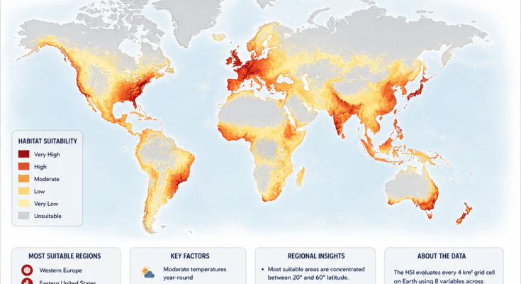
Humans can live in an astonishing range of environments.
We have cities above the Arctic Circle.
Millions live in deserts.
Mountain communities survive thousands of meters above sea level.
Tropical megacities contain tens of millions of people.
Yet that does not mean every part of Earth is equally easy to inhabit.
When we compare climate, freshwater availability, agricultural potential, terrain, natural hazards and access to infrastructure, clear geographic patterns begin to emerge.
Large portions of Western Europe, eastern North America, coastal East Asia and temperate parts of the Southern Hemisphere combine several conditions that have historically favored dense and long-lasting human settlement.
Meanwhile, extreme deserts, polar regions, high mountains and some very humid tropical interiors create greater challenges.
But the key word is suitability—not possibility.
People can and do thrive well outside the world’s most naturally comfortable environments.
What Makes a Place Suitable for Humans?
There is no single scientific number that perfectly measures human habitability.
A useful assessment would need to consider several factors at once.
Among the most important are:
- Moderate temperatures
- Reliable freshwater
- Productive agricultural land
- Relatively accessible terrain
- Manageable natural-hazard risk
- Transportation and infrastructure
- Economic opportunities
- Health and sanitation
- Political and social conditions
The first four are heavily influenced by physical geography.
The others depend much more on human institutions and technology.
That distinction matters because a naturally difficult environment can become highly livable with enough infrastructure.
Dubai is an obvious example.
So is Las Vegas.
Both support large urban populations in environments where water and heat would otherwise severely constrain settlement.
Humans Have a Surprisingly Narrow Climate Niche
Despite our technology, humans are not distributed randomly across Earth’s climates.
A major 2020 study published in Proceedings of the National Academy of Sciences found that human populations have historically been heavily concentrated within a relatively narrow climatic range.
The main concentration occurs around 11–15°C mean annual temperature. (PubMed)
Interestingly, crops and livestock also tend to be concentrated around similar climatic conditions.
That makes sense.
A climate that supports agriculture, livestock, outdoor work and reliable water supplies is likely to support large human populations as well.
Researchers also identify a second population concentration around warmer temperatures associated particularly with South Asian monsoon climates. (Nature)
This helps explain why both temperate Europe and tropical South Asia can support extremely dense populations despite having very different climates.
Western Europe: One of the World’s Strongest Settlement Zones
Western Europe stands out as one of the most consistently favorable regions for dense human settlement.
Countries such as:
France, Germany, the Netherlands, Belgium, the United Kingdom, northern Italy and parts of Switzerland
combine several advantages.
Moderate Climate
Much of Western Europe experiences relatively mild temperatures.
Winters are generally less severe than those at comparable latitudes in continental interiors, partly because of Atlantic Ocean influence.
Summers are usually warm enough for agriculture without reaching the extreme heat experienced in many subtropical regions.
That does not mean the weather is always comfortable.
Europe experiences heat waves, floods and severe winter events.
But over the long term, its climate has supported dense agricultural and urban settlement.
Abundant Freshwater
Western Europe contains extensive river systems including:
- Rhine
- Seine
- Rhône
- Thames
- Elbe
- Danube tributaries
Rainfall is also relatively reliable across much of the region.
Historically, rivers provided:
drinking water, irrigation, transportation, power and trade routes.
Many of Europe’s greatest cities developed directly along them.
Productive Agricultural Land
The European Plain stretches across a huge portion of the continent.
Relatively flat terrain combined with fertile soils made large-scale agriculture possible.
This allowed populations to grow centuries before modern industrial food systems existed.
Dense Infrastructure
Today another factor is just as important:
Europe is already built for people.
Roads, railways, hospitals, electrical grids, ports, schools, water systems and telecommunications networks are extremely dense.
Natural suitability and centuries of infrastructure investment reinforce one another.
That is why an area that was historically attractive for settlement can become even more attractive over time.
The Eastern United States
Another major settlement belt appears across the eastern United States.
The contrast with the interior West is striking.
The eastern half of the country generally offers:
- More rainfall
- More rivers
- Extensive agricultural land
- Fewer extremely arid regions
- Dense transportation networks
- Long-established cities
This helps explain why the eastern United States historically became far more densely populated than much of the Mountain West.
The Great Lakes and Northeast
The Great Lakes created one of North America’s great settlement zones.
Cities such as:
Chicago, Detroit, Cleveland, Buffalo and Toronto
grew around enormous freshwater resources and transportation routes.
Farther east, the Atlantic corridor contains:
Boston, New York, Philadelphia, Baltimore and Washington.
Ports, rivers, industry and immigration reinforced the region’s growth.
The Southeast
The southeastern United States is warmer and more humid but remains highly suitable for large populations.
Rainfall is generally abundant.
Agricultural growing seasons are long.
And modern air conditioning has made hot summers much easier to tolerate.
This is an important reminder that technology can alter practical habitability.
Places that were climatically uncomfortable can become highly attractive once people can control indoor temperature.
Coastal East Asia
Another major high-suitability zone runs through portions of coastal East Asia.
This region contains some of the densest human settlement on Earth.
Think of:
- Eastern China
- South Korea
- Japan
These areas benefit from combinations of productive lowlands, river valleys, rainfall, maritime access and centuries of agricultural development.
China’s Great River Basins
Eastern China contains some of the world’s most important agricultural landscapes.
The Yangtze River basin supports enormous populations.
The North China Plain around the lower Yellow River has also been one of the centers of Chinese civilization for thousands of years.
Large river systems provided irrigation and fertile floodplain soils.
They also created serious flood risk.
Again, suitability does not mean absence of hazards.
Some highly productive settlement zones are also dangerous.
Japan’s Coastal Concentration
Japan is mountainous.
Large parts of the country are difficult to settle densely.
So population concentrates heavily on coastal plains.
Tokyo, Osaka, Nagoya and other major metropolitan regions occupy relatively limited flat territory.
That creates an important pattern:
A country can have challenging overall geography while containing exceptionally suitable pockets.
South Asia and the Monsoon Belt
At first glance, South Asia seems different from the temperate regions highlighted elsewhere.
It is hotter.
Humidity can be extreme.
Floods are frequent.
Yet the region contains one of humanity’s greatest population concentrations.
Why?
Because warmth alone does not determine habitability.
Water Changes Everything
South Asia receives enormous quantities of seasonal monsoon rainfall.
Great river systems include:
- Ganges
- Brahmaputra
- Indus
Their floodplains have supported agriculture for thousands of years.
Rice, wheat and other crops can support dense populations where water and fertile land coincide.
The 2023 human-climate-niche research identifies a secondary population-density peak associated largely with warm monsoon climates in South Asia. (Nature)
So the world’s most densely inhabited environments do not all resemble Western Europe.
There are multiple successful combinations of climate and water.
Southeastern Australia
Australia illustrates the opposite phenomenon.
The continent is enormous.
But its population is concentrated mainly around a relatively narrow coastal fringe.
The southeastern portion—including areas around:
Sydney, Melbourne, Canberra and Adelaide
has generally been much more favorable to large settlement than Australia’s dry interior.
Why the Interior Is So Sparse
Much of central Australia is arid or semi-arid.
Water is limited.
Agriculture is difficult.
Distances are enormous.
Temperatures can be extreme.
The southeastern and eastern coastal regions receive more reliable rainfall and contain much of the country’s major infrastructure.
That is why Australia’s population map hugs the coastline.
New Zealand
New Zealand also scores well under many broad habitability criteria.
It combines:
- Temperate climate
- Abundant rainfall
- Freshwater
- Agricultural land
- Extensive coastline
Its relatively small population means the country is far less densely settled than Western Europe or East Asia.
But low population density does not necessarily mean low suitability.
Historical population, remoteness and migration also matter.
Southeastern South America
South America contains several favorable settlement zones that can be overlooked on global maps.
One important region includes parts of:
- Southeastern Brazil
- Uruguay
- Eastern and central Argentina
This broad area includes some of the continent’s largest cities and most productive farmland.
The Pampas
Argentina’s Pampas are among the world’s important temperate agricultural regions.
Flat terrain and fertile soils support:
- Wheat
- Maize
- Soybeans
- Cattle
Buenos Aires grew near this enormous agricultural hinterland and the Río de la Plata.
Southeastern Brazil
Brazil’s population is strongly concentrated toward the Atlantic coast.
The São Paulo and Rio de Janeiro regions benefit from long-established infrastructure, ports and economic concentration.
Climate and topography vary significantly, but the region has become one of the Southern Hemisphere’s largest urban-industrial zones.
Why Deserts Rank Lower
Large deserts are among the most obvious low-suitability environments.
Examples include:
- Sahara
- Arabian Desert
- Gobi
- Australian interior
- Atacama
The main limitation is usually water.
Humans can tolerate dry air.
Cities can cope with high temperatures using technology.
But large populations require enormous quantities of freshwater.
Water is needed not only for drinking but for:
agriculture, sanitation, industry and energy.
Modern desalination allows wealthy coastal desert cities to overcome part of this limitation.
But doing so requires substantial energy and infrastructure.
So deserts are not uninhabitable.
They are simply more expensive and technologically demanding places to support dense populations.
Why Polar Regions Are Difficult
At the opposite climatic extreme lie the Arctic and Antarctic environments.
Major challenges include:
- Extreme cold
- Short growing seasons
- Frozen soils
- Limited agriculture
- Seasonal darkness
- High infrastructure costs
Northern Canada, Greenland and Siberia support permanent communities.
But population densities are extremely low.
Antarctica has no permanent civilian population at all—only rotating scientific and support personnel.
Technology makes human presence possible.
It does not make the environment naturally favorable for millions of people.
Mountains Create Another Barrier
High mountain regions can have abundant water and relatively moderate temperatures at some elevations.
But steep terrain makes large settlements difficult.
Mountains increase the cost of:
- Roads
- Railways
- Airports
- Housing
- Agriculture
- Utility networks
High elevations can also produce physiological challenges because of reduced oxygen.
This is why major populations often cluster in:
river valleys, plateaus and foothills
rather than on the steepest mountains themselves.
Tropical Rainforests Are More Complicated Than They Look
The infographic treats some tropical rainforest regions as poorly suited to large-scale settlement.
There are reasons for this, but the point requires caution.
Rainforests obviously have enormous amounts of biological productivity and water.
Yet conditions can create challenges for certain forms of agriculture and infrastructure.
Many tropical soils are less fertile than the lush vegetation might suggest because nutrients are stored rapidly in living biomass rather than deep soil.
Heavy rainfall can leach nutrients.
Heat and humidity can increase disease-vector pressures.
Dense forests also historically made transportation more difficult.
But calling rainforest regions simply “unsuitable” would be misleading.
Millions of people have lived successfully in tropical environments for thousands of years.
Suitability depends strongly on technology, culture and the type of economy being considered.
Why Population Density Is Not the Same as Habitability
This distinction is critical.
A suitable environment does not automatically become densely populated.
And a difficult environment can become highly populated.
Population patterns also depend on:
- History
- Trade
- Migration
- Political stability
- Colonialism
- Industrialization
- Employment
- Government policy
Singapore has one of the world’s highest population densities despite having limited agricultural land.
Mongolia has extremely low density even though significant areas can support human habitation.
The Netherlands supports an enormous population despite substantial flood exposure because centuries of engineering transformed the landscape.
Human settlement is therefore partly geographical and partly constructed.
Infrastructure Can Rewrite the Map
Consider two regions with identical climates.
One has:
hospitals, paved roads, electricity, clean water, schools and broadband.
The other lacks reliable transportation and sanitation.
Their practical suitability for modern human life would be very different.
This is why infrastructure should not be treated as a natural environmental variable.
It is something societies build.
And once built, it can dramatically expand where people can live comfortably.
Air conditioning opened hot regions to much denser urban settlement.
Desalination supports cities in extremely dry climates.
Dams move water hundreds of kilometers.
Heating allows cities to exist in very cold environments.
Humans continuously modify their own habitat.
There Is No Single “Best Place on Earth”
A global habitability map can be useful.
But the word best immediately raises another question:
Best for what?
Best for agriculture?
Best natural climate?
Best access to drinking water?
Lowest natural-disaster exposure?
Best economy?
Best healthcare?
Best place to survive without modern infrastructure?
Those questions could produce completely different maps.
A remote temperate valley might have excellent natural conditions but limited employment.
A dense coastal megacity might have fantastic services while facing serious flood risk.
A desert city may offer high living standards while being completely dependent on imported food and desalinated water.
So no scientifically meaningful global habitability map can be reduced to climate alone.
Climate Change Is Moving the Human Climate Niche
There is another reason today’s suitability patterns should not be treated as permanent.
Climate is changing.
A 2023 study in Nature Sustainability estimated that climate change had already moved more than 600 million people—around 9% of the global population—outside the historical human climate niche. (Nature)
Under higher warming scenarios, many more people could experience climatic conditions historically associated with much lower human population density.
The researchers found that under warming around 2.7°C above preindustrial conditions by late century, roughly 22–39% of humanity could find itself outside the historical climate niche. (Nature)
That does not mean those regions suddenly become physically impossible to inhabit.
People adapt.
Buildings change.
Agriculture changes.
Migration occurs.
Technology helps.
But adaptation costs increase, especially in areas exposed to extreme heat.
Very High Heat Is Particularly Important
The same research highlights regions with mean annual temperatures of 29°C or more.
Historically, only a small fraction of Earth’s land had such conditions, mostly around the Sahara.
Extreme heat can affect:
- Human health
- Outdoor labor
- Agricultural productivity
- Water demand
- Energy consumption
And humidity makes high temperatures even more dangerous because it reduces the body’s ability to cool itself through sweating. (Nature)
That is why climate change could alter future settlement suitability even in places that currently support enormous populations.
The Real Map Is Constantly Changing
The Earth’s mountains will not move much during our lifetimes.
But the geography of human habitability can change remarkably quickly.
A new reservoir can turn dry land into irrigated farmland.
A highway can transform an isolated valley.
Air conditioning can enable a desert metropolis.
War can empty a perfectly fertile region.
Economic opportunity can attract millions into climates that are far from ideal.
Climate change can make previously comfortable locations hotter and more water-stressed.
So there is no permanent map of where humans “should” live.
There is only a changing relationship between nature and our ability to adapt to it.
The Bigger Lesson
Why have humans historically clustered in certain parts of the planet?
Because several favorable conditions often overlap there.
Moderate temperatures.
Reliable water.
Food-producing landscapes.
Accessible terrain.
And, increasingly, infrastructure.
That helps explain the great settlement belts visible across:
Western and Central Europe
Eastern North America
East Asian coastal plains
South Asian river and monsoon regions
Southeastern Australia
New Zealand
Southeastern South America
But it would be wrong to conclude that people outside these regions are living in “bad” places.
Humans have adapted to almost every terrestrial environment on Earth.
The map is ultimately not a ranking of where people can live.
It is an illustration of where nature historically makes large-scale settlement easier—and where humans have had to work harder to overcome geography.
Source and Accuracy Note
The infographic’s attribution to a “2023 Human Habitat Suitability Index” from Yale Center for Environmental Law & Policy could not be verified in Yale’s published project listings, and I would remove that attribution unless you have the original dataset or paper. Yale’s documented global environmental ranking project is the Environmental Performance Index. (Yale School of the Environment)
For a defensible scientific basis, this article instead draws on peer-reviewed research into the human climate niche, including the 2020 PNAS study showing a long-standing concentration of humans around approximately 11–15°C mean annual temperature and the 2023 Nature Sustainability study examining how climate warming is shifting populations outside historical climatic conditions. (PubMed)