
Europe’s political borders are easy to see.
Its water borders are almost invisible.
Rain falling a few kilometers apart can begin completely different journeys. One drop may eventually reach the Atlantic Ocean. Another may flow toward the Baltic. A third could travel thousands of kilometers through the Danube system before entering the Black Sea.
And in eastern Europe, water falling inside the enormous Volga basin ultimately reaches the Caspian Sea—an inland body of water with no natural outlet to the world’s oceans.
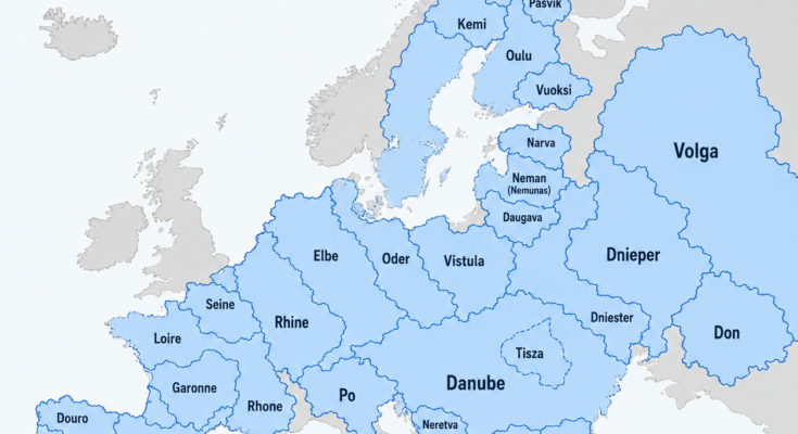
The map above shows some of Europe’s major drainage basins, the areas of land where precipitation eventually drains toward the same river system.
These basins ignore national borders.
The Rhine basin extends across nine countries.
The Danube basin reaches into 19 countries.
The Dnieper connects Russia, Belarus and Ukraine.
The Vistula dominates much of Poland.
And the Volga basin covers an enormous portion of European Russia.
Once you understand drainage basins, Europe starts to look very different.
First: What Is a River Basin?
A river basin, also called a drainage basin or catchment, is all the land whose water eventually drains into a particular river system.
Imagine rain falling on a mountain.
Water landing on one side of the ridge may flow west.
Water falling only a few meters away on the opposite slope may flow east.
That ridge forms part of a watershed divide.
Streams combine into larger streams.
Those combine into rivers.
Tributaries join the main river.
Eventually the entire network reaches a sea, ocean, lake or other terminal basin.
So when the map colors the enormous Danube region blue, it does not mean the Danube River itself is hundreds of kilometers wide.
It means virtually every stream within that region ultimately contributes water to the Danube system.
This is why drainage-basin maps reveal geographical relationships that ordinary maps hide.
Europe Is Divided by Water, Not Just Borders
A river doesn’t care whether it has crossed from Germany into France or Slovakia into Hungary.
Water simply follows gravity.
As a result, Europe’s natural hydrological boundaries frequently cut straight across political ones.
The European Environment Agency’s ECRINS system was designed specifically to model these relationships, organizing European waterways into interconnected catchments, sub-basins and river systems.
This has practical consequences.
If pollution enters a river upstream in one country, communities far downstream in another country may eventually receive it.
If one country builds dams, changes water withdrawals or alters floodplains, the effects may cross borders.
That is why river basins increasingly form the natural unit for international water management.
The Volga: Europe’s Largest River Basin
The enormous blue region in western Russia belongs to the Volga.
It is Europe’s largest river basin.
The Volga itself is also Europe’s longest river, running approximately 3,530 kilometers before entering the Caspian Sea.
Its catchment covers roughly 1.36–1.4 million square kilometers.
That area is enormous.
It covers a significant portion of European Russia and includes some of the country’s most important cities, industries and agricultural regions.
The Volga Does Not Reach an Ocean
This makes the Volga especially interesting.
Most of Europe’s great rivers eventually connect with the Atlantic Ocean or one of its marginal seas.
The Volga does not.
It empties into the Caspian Sea.
The Caspian is an endorheic, or closed, basin.
Water reaches it but has no natural river outlet to an ocean.
Instead, water ultimately leaves primarily through evaporation.
So the giant Volga watershed is hydrologically separated from the world’s ocean system.
The Volga Basin Is an Economic Heartland
The importance of the Volga goes far beyond geography.
Research on the river basin notes that it contains a very large share of Russia’s population and industrial and agricultural activity.
Major cities associated with the river system include:
- Nizhny Novgorod
- Kazan
- Samara
- Saratov
- Volgograd
- Astrakhan
The river has also been heavily modified by dams and reservoirs for:
- Hydroelectric power
- Navigation
- Water supply
- Industry
The result is one of Europe’s most economically important—and heavily engineered—river systems.
The Danube: Europe’s Great International Basin
If the Volga dominates eastern Europe by size, the Danube dominates central and southeastern Europe by international reach.
The Danube River Basin covers about 801,000 square kilometers, making it Europe’s second-largest river basin.
But its most remarkable statistic is political:
19 countries share part of the Danube basin.
That makes it the world’s most international river basin.
Approximately 79 million people live within it.
The Danube Begins in Germany and Ends in the Black Sea
The Danube begins in Germany’s Black Forest.
From there it flows generally eastward across central and southeastern Europe before reaching the Black Sea through the Danube Delta.
The main river passes through or forms borders involving ten countries.
Its wider drainage basin reaches nine more.
Four national capitals stand directly on the Danube:
- Vienna
- Bratislava
- Budapest
- Belgrade
Several other capitals are connected through tributaries.
Few rivers connect so many countries, languages and cultures.
Hungary Is Almost Entirely Inside the Danube Basin
The map reveals something particularly interesting about Hungary.
Essentially the entire country drains into the Danube system.
According to the International Commission for the Protection of the Danube River, 100% of Hungary’s territory lies within the basin.
More than 96% of Austria and Slovakia and roughly 97% of Romania are also inside it.
This explains why the Danube is not simply another river in those countries.
It is the central organizing structure of their physical geography.
The Tisza: A Basin Inside a Basin
The map shows the Tisza using a dashed outline inside the larger Danube region.
That distinction is important.
The Tisza has its own drainage basin, but it is also a tributary of the Danube.
Water flowing into the Tisza eventually reaches the Danube and then the Black Sea.
So river basins can exist hierarchically.
A small stream may have its own catchment.
That stream feeds a larger river with a larger catchment.
That river may then join an even larger river system.
The Tisza is one of the Danube’s most important tributaries and drains large portions of the Carpathian Basin.
This is why a basin map can contain sub-basins within larger basins without contradiction.
The Dnieper: A Giant Basin Across Eastern Europe
West of the Volga lies another enormous river system: the Dnieper, or Dnipro.
Its drainage basin covers roughly half a million square kilometers across:
- Russia
- Belarus
- Ukraine
The river ultimately empties into the Black Sea.
The Dnieper is particularly important to Ukraine.
A large share of Ukraine’s territory and water resources is connected to the basin.
Major cities along the system include:
- Kyiv
- Dnipro
- Zaporizhzhia
The river has also been extensively dammed, creating enormous reservoirs used historically for electricity, industry, transportation and irrigation.
The Dnieper Shows Why Rivers Become Strategic
Large river basins provide more than drinking water.
They can support:
- Hydroelectric power
- Agriculture
- Industrial water
- Navigation
- Cities
- Fisheries
- Ecosystems
That makes them economically valuable—and strategically important.
The Dnieper demonstrates how a single river system can become deeply tied to the infrastructure and economy of an entire country.
The Don: Toward the Sea of Azov
East of the Dnieper lies the Don basin.
The Don flows through southwestern Russia before reaching the Sea of Azov, which connects through the Black Sea and Mediterranean system to the Atlantic.
Its catchment covers a large part of the steppe region.
The river became especially significant for transportation after the construction of the Volga–Don Canal, which created a navigable connection between the Volga-Caspian system and the Don-Black Sea system.
This is an important reminder:
Natural drainage basins are divided by watersheds, but humans can sometimes connect them artificially with canals.
The Vistula: Poland’s Great River Basin
Poland is visually dominated by the Vistula, or Wisła.
The Vistula basin covers approximately 194,000 square kilometers and encompasses close to 60% of Poland.
The river begins in the Carpathian region of southern Poland and flows north toward the Baltic Sea.
Along the way it passes major cities including:
- Kraków
- Warsaw
- Toruń
- the Gdańsk region
The Vistula is Poland’s longest river.
Its basin is therefore not simply a geographical feature—it covers the demographic and economic heart of much of the country.
Poland Is Split Mainly Between the Vistula and Oder Systems
To the west lies the Oder, or Odra.
The Oder basin drains much of western Poland along with portions of Czechia and Germany.
The Oder eventually reaches the Baltic Sea through the Szczecin Lagoon region.
This creates a fundamental hydrological division within Poland:
Much of central and eastern Poland drains toward the Vistula.
Much of western Poland drains toward the Oder.
A watershed rather than a political boundary decides which direction the water takes.
The Elbe: From Czechia Through Germany
West of the Oder lies the Elbe basin.
The Elbe begins in Czechia and crosses Germany before reaching the North Sea near Hamburg.
Prague itself does not sit on the Elbe proper.
It sits on the Vltava, or Moldau, which is one of the Elbe’s major tributaries.
So rain falling around Prague can ultimately travel north through the Elbe system and enter the North Sea in Germany.
That illustrates one of the most interesting features of basin maps:
A city hundreds of kilometers from another country can still be hydrologically connected to it.
The Rhine: Europe’s Economic River Corridor
The Rhine basin looks much smaller than the Danube or Volga, but economically it is one of Europe’s most important.
The Rhine’s international catchment covers roughly 200,000 square kilometers across nine countries and supports around 60 million inhabitants.
The river connects the Alps with the North Sea.
Its drainage network reaches parts of:
- Switzerland
- Liechtenstein
- Austria
- Germany
- France
- Luxembourg
- Belgium
- Netherlands
- a very small part of Italy
The basin contains some of Europe’s most heavily industrialized and urbanized territory.
The Rhine Connects Switzerland to Rotterdam
Water falling in the Swiss Alps can eventually travel through:
Switzerland → Germany → Netherlands → North Sea.
Along the way, the Rhine passes major economic regions and receives tributaries such as:
- Aare
- Neckar
- Main
- Moselle
- Ruhr
The river became one of Europe’s great commercial corridors.
The International Commission for the Protection of the Rhine describes it as an important axis for navigation, industry, drinking water, hydropower and urban water management.
Around 30 million people receive treated drinking water derived from the Rhine system, according to the commission.
France: Several Great Basins Instead of One Dominant River
France has a particularly interesting basin map because no single river dominates the country as completely as the Vistula does Poland.
Instead, France is divided among several major systems.
Seine
The Seine drains north-central France.
It passes directly through Paris before reaching the English Channel.
The Paris metropolitan region therefore sits inside one of Europe’s most politically and economically important drainage basins.
Loire
The Loire basin dominates much of central and western France.
The Loire is the longest river entirely within France and eventually reaches the Atlantic Ocean.
Its valley is famous for historic towns, vineyards and castles.
Garonne
Southwestern France drains substantially through the Garonne.
The river passes through Toulouse and Bordeaux before joining the Dordogne system and reaching the Atlantic through the Gironde estuary.
Rhône
Southeastern France belongs largely to the Rhône basin.
The Rhône begins from the Swiss Alps, flows through Lake Geneva and enters France before turning south toward the Mediterranean.
This creates one of Europe’s major hydrological divides:
Rain falling on one side of eastern France eventually reaches the Atlantic or North Sea.
Rain falling on another side may end up in the Mediterranean.
The Iberian Peninsula: Rivers Flow Mostly West
Spain and Portugal show another distinct pattern.
Several great rivers cross or approach the Spanish-Portuguese border before reaching the Atlantic.
Douro
The Douro, called Duero in Spain, begins in Spain and flows west across northern Portugal.
It reaches the Atlantic at Porto.
Its valley is internationally famous for wine production.
Tagus
The Tagus, or Tajo/Tejo, is the longest river of the Iberian Peninsula.
It flows west through Spain and Portugal before reaching the Atlantic at Lisbon.
Guadiana
Farther south, the Guadiana also crosses the peninsula toward the Atlantic and forms sections of the Spain-Portugal border.
Guadalquivir
The Guadalquivir drains much of Andalusia.
It passes Córdoba and Seville before entering the Atlantic near the Gulf of Cádiz.
Its basin supported some of Iberia’s most important historic cities.
Ebro
Spain’s great exception is the Ebro.
Instead of flowing west into the Atlantic, it flows east into the Mediterranean.
That makes Spain an excellent example of how mountain ranges divide water systems.
Italy’s Po Basin
Northern Italy is dominated by the Po basin.
The Po flows eastward across the broad Po Valley before reaching the Adriatic Sea.
The surrounding plain contains some of Italy’s:
- Most productive agricultural land
- Largest cities
- Densest industrial regions
- Most important transportation corridors
Cities including Turin and parts of the wider Milan region lie within the hydrological system.
The basin sits between the Alps to the north and the Apennines to the south.
Those mountain chains effectively funnel water into the Po Valley.
The Balkans: Small Basins Packed Closely Together
The Balkans look dramatically different from the giant Volga and Danube regions.
Mountainous terrain creates a collection of smaller basins lying close together.
The map highlights several.
Neretva
The Neretva drains parts of Bosnia and Herzegovina and Croatia before reaching the Adriatic.
The river passes through Mostar and is one of the best-known river systems of the western Balkans.
Drin
The Drin system drains large portions of Albania and neighboring territories toward the Adriatic.
Its basin is connected with major Balkan lakes and mountain watersheds.
Vjosa
The Vjosa, known upstream in Greece as the Aoös, flows through Greece and Albania before reaching the Adriatic.
It has gained international attention because substantial stretches retain relatively natural river morphology.
Vardar
The Vardar, known as Axios in Greece, drains much of North Macedonia before entering the Aegean Sea.
Skopje lies on the river.
Struma
The Struma, or Strymon, flows from Bulgaria through Greece toward the Aegean.
Maritsa
The Maritsa, or Evros/Meriç, is another major southeastern European river.
Its basin extends through Bulgaria, Greece and Turkey.
Sections of the river form an international boundary.
These systems demonstrate what happens in mountainous regions:
Watersheds can sit very close to one another, producing numerous separate river basins within a relatively small geographic area.
Northern Europe: Water Everywhere
Finland and northern Scandinavia show another completely different hydrological landscape.
The region was heavily shaped by glaciers.
Thousands of lakes, rivers and interconnected waterways dominate the geography.
Kemi
The Kemijoki/Kemi basin covers a large portion of northern Finland and drains into the Gulf of Bothnia.
It is Finland’s longest river system and has been heavily developed for hydroelectric power.
Oulu
The Oulu River system also drains toward the Gulf of Bothnia.
Its lakes and waterways historically served transportation and later hydropower.
Vuoksi
The Vuoksi system is particularly fascinating.
It drains Lake Saimaa in Finland eastward into Lake Ladoga.
Lake Ladoga then drains through the Neva River into the Gulf of Finland.
So water beginning deep inside Finland can eventually reach the Baltic through Russia.
Narva
The Narva drains Lake Peipus toward the Gulf of Finland and forms part of the border between Estonia and Russia.
Daugava
The Daugava, known upstream as the Western Dvina, flows through Russia, Belarus and Latvia before reaching the Baltic Sea at Riga.
Neman
The Neman/Nemunas crosses Belarus and Lithuania before reaching the Baltic region.
Again, the river system pays no attention to today’s borders.
Tana and Pasvik: Rivers of the Far North
At the northern edge of Europe, the map includes the Tana and Pasvik basins.
These rivers belong to the Arctic and Barents Sea drainage world rather than the Baltic or Atlantic systems farther south.
The Tana forms part of the border between Norway and Finland.
The Pasvik flows through a highly international northern landscape involving Finland, Russia and Norway.
The population is small compared with the Rhine or Danube basins, but these northern systems are environmentally significant and support important aquatic ecosystems.
Europe’s Great Continental Watersheds
Once all these basins are placed together, invisible continental divides begin to appear.
Europe’s water ultimately reaches several major destinations.
Atlantic Ocean and connected seas
Systems such as the:
- Loire
- Garonne
- Douro
- Tagus
- Rhine
- Elbe
ultimately belong to the Atlantic drainage world, directly or through seas such as the North Sea.
Baltic Sea
Major systems include:
- Vistula
- Oder
- Neman
- Daugava
- Neva-related drainage
- numerous Scandinavian and Finnish rivers
Black Sea
The largest is the:
Danube
alongside other systems including:
- Dnieper
- Dniester
Mediterranean Sea
Major examples include:
- Rhône
- Ebro
- Po
- Vardar
- Struma
Caspian Sea
The giant European example is:
Volga
Because the Caspian has no natural ocean outlet, the Volga belongs to an internally draining basin.
Why River Basins Matter More Than Ever
These maps aren’t merely geography trivia.
They are essential for environmental management.
A river basin can contain:
- Drinking-water supplies
- Farms
- Hydropower stations
- Industrial plants
- Cities
- Wetlands
- Shipping corridors
- Fisheries
And all of them are connected by flowing water.
That means problems move downstream.
Fertilizer entering a tributary in one country can eventually contribute nutrients to a sea hundreds of kilometers away.
Flood-control decisions upstream can influence downstream communities.
Dams can change sediment transport and fish migration.
Water extraction can alter river flows.
Climate change can intensify both drought and flood pressures.
The Danube Commission’s environmental work, for example, requires cooperation precisely because 19 countries occupy the same drainage system.
The Rhine has a similar international management framework because its catchment extends through nine countries.
A River Basin Is Often More Natural Than a Political Border
This may be the biggest lesson of the map.
Political boundaries are created by people.
Drainage boundaries are created primarily by terrain.
Mountain ridges, slopes and elevation determine where water flows.
That means a river basin is often a more physically coherent geographical region than the country borders drawn across it.
Consider the Danube.
Austria, Hungary, Slovakia, Croatia, Serbia and Romania have different languages and histories.
Hydrologically, however, much of their territory belongs to one connected system.
The same rainwater network links them.
The same is true of the Rhine, Dnieper, Daugava and dozens of other European rivers.
The Map Also Shows Why Mountains Matter So Much
Europe’s major mountain ranges act like giant water towers and walls.
The Alps help divide drainage toward the:
- Rhine
- Rhône
- Danube
- Po
The Carpathians feed portions of the:
- Danube
- Tisza
- Dniester
- Vistula systems
The Pyrenees separate major French and Spanish drainage areas.
The Scandinavian Mountains divide rivers flowing toward the Atlantic from those draining eastward toward Sweden and the Baltic.
Even relatively modest uplands can determine which sea receives water from a huge landscape.
The highest point isn’t always where the largest river begins.
What matters is the shape of the surrounding terrain.
The Most Surprising Basin on the Map
For many viewers, the Danube appears most impressive because it crosses so many countries.
But physically, the Volga basin is even larger.
At roughly 1.36 million square kilometers, it dwarfs many European countries and is substantially larger than the Danube’s roughly 801,000-square-kilometer basin.
Yet the two rivers behave very differently.
Volga → Caspian Sea
Danube → Black Sea → Mediterranean → Atlantic-connected global ocean
One ends in a closed inland basin.
The other eventually connects with the world’s oceans.
One Drop of Rain Can Reveal the Geography of a Continent
Imagine dropping rain onto several European cities.
Rain falling in Warsaw enters the Vistula system and ultimately reaches the Baltic.
Rain falling around Budapest enters the Danube and travels toward the Black Sea.
Water near Paris flows through the Seine toward the English Channel.
Water entering tributaries around Frankfurt eventually joins the Rhine and reaches the North Sea.
Water falling across the Volga basin follows an entirely different fate, ultimately ending in the Caspian.
Nothing on an ordinary road map makes those relationships obvious.
A drainage-basin map does.
And that is what makes maps like this so fascinating.
Europe may be divided politically into dozens of countries.
Hydrologically, it is divided into a completely different set of territories—natural regions whose borders are mountain ridges and whose highways are rivers.
Source and Map Note
The accompanying graphic shows selected major drainage basins rather than every European catchment. Basin boundaries can vary slightly according to dataset scale and methodology, particularly around small coastal catchments and complex lake systems. The European Environment Agency’s ECRINS database organizes European hydrology into interconnected elementary catchments, sub-basins and river-basin units. The Danube basin figures cited here use current information from the International Commission for the Protection of the Danube River; Rhine figures use the International Commission for the Protection of the Rhine.